How long did it take to walk the entire AT?
5 months, 1/2 day
How many miles a day did you hike?
We averaged 17 miles a day for days hiked. That includes partial days such as when we only hiked a short distance to reach a town.
How much did you pack weigh?
With food and water for 3-5 days, about 30-35 pounds.
Were you ever afraid?
No.
Did you ever think you weren't going to finish?
Although we sometimes got tired of being on the trail, we always felt we would finish.
What was the hardest part of the trail?
The White Mountains.
What was the prettiest part of the trail?
Most of the trail is pretty in it's own way but we liked the White Mountains best, closely followed by Maine, then the Mt. Rogers area.
What was the best part of hiking the AT?
The best part was being with Brad for such a long time, the scenery & wildlife, and, something of a surprise, the wonderful and wonderfully kind people we met.
What was the worst part of hiking the trail?
The physical demands, day after day, got old. The inadequate & boring diet, being hungry all the time.
Oedipus

Oedipus 1987(?)-2007
Oedipus was homeless and kept breaking into our daughter's apartment at Brandeis. At Christmas break that year, Kris brought her home. Oedipus spent the next several years terrorizing the dog until we moved onto the boat and the dog went to live with our son, Brian. She was a great 'boat cat', instinctively knew where to go to minimize seasickness (both Oedipus & Pat usually got sick the first day out on any trip) and survived two 'trips' overboard. She died in June, 2007, of a brain tumor.
Click on picture for slideshow of cat pictures.


Navigating the ICW
 Placed sometimes as far apart as 1 mile, red and green markers, some with flashing lights, mark the channel boundaries for safe water. The red markers are even numbered and triangular; the green, rectangular and odd numbered. Water depths outside the channel often shallow very quickly. Constant attention must be paid to avoid grounding.
The Big IC
I awoke around 5:00 am to the joyful chattering of two otters gamboling about the boat. I rushed on deck to just miss getting a picture or at least a recognizable picture of these playful creatures. They were too quick. Still, I had never seen otter in the wild and it was exciting.
We had been at Coinjock for several days and with Pat feeling much better we planned to head out that morning. Our friends, Michael and Joy of Fiona Rois, had pulled in the day before after spending the previous night aground in water that, according to the chart, should have been 4 or 5 feet deeper than it actually was. I guess the water hadn't looked at the chart. The weather forecast called for light winds and clear skies followed by deteriorating conditions over the next several days (gale force winds and freezing temperatures). If we didn't leave right away, we would be stuck in Coinjock for 3 or 4 more days.
Shortly after sunrise, Friday, December 14, we cast off and headed down the Cut. Our trip would take us down the North River and into the Alligator River, stopping for the night at the Alligator River Marina. With calm winds, sunny skies and deep water, our only concern was a fishhook turn where the channel had reportedly silted in making the charts inaccurate. Talking to the marina manager and others with local knowledge, however, reassured us that following the day markers would ensure a safe passage.
The trip proved uneventful. We saw a few more otter and enjoyed a quiet day. We pulled into the Alligator River Marina late afternoon. The marina is an artificial harbor that offers all of the services and entertainment of a gas station convenient market. The nearest restaurant or store is 12 miles away. The Marina does have a full service grill that offers a wide range of fried food and burgers. In other words, a place where you can eat and get gas.
While the marina may have been a little short on amenities, the harbor is very protected and we were happy to be securely tied up there during the next three days as the wind gusted up to 40 knots. It got so windy that the Alligator River Swing Bridge closed on Sunday because it wasn't safe to open. Days confined to the boat provide an opportunity to plan, do repairs, read and visit with fellow cruisers. Unfortunately, we had no high speed internet service and sporadic cell phone service so surfing the net and responding to emails was a challenge. As we planned to drive to Ohio and then Florida over the holidays, we needed to rent a car. Unfortunately, there were few car rental options locally and none allowed driving as far as Ohio (I think you weren't allowed to cross the Mason-Dixon Line). Pat finally located a Hertz in Greenville (50 miles away) that met our needs; we just had to figure out how to get there.
Because the marina was so well protected and relatively inexpensive, we considered leaving the boat there over the holidays. However, when I asked the Dock Master, 18 year old Josh, about leaving the boat, I was told that I had to get the permission of the owners. I asked to speak to the owners and was told, "They're away." "When will they get back?" "Not sure." "Can you call them?" "Well, I don't know about that. They don't like to be bothered when they're away." "But, I don't understand. The marina is practically empty. What's the problem?" "They can't rent slips on a permanent basis." "I'm not talking about permanent; only till after Christmas." "You have to talk to the owners about that." "When can I talk to them?" "Not sure." By now, I sensed the futility of going on; that the gnawing feeling in my stomach and the slight rise in the pitch in my voice suggested the delegation of this task to my more politically astute 1st Mate would be the most prudent course of action. The owners actually returned while we were still there. I left several requests to speak with them but they never responded.
Tuesday dawned cold, bright and clear, winds 5-10 knots NW. We scraped ice off the bimini, loosed the lines, passed through the Alligator River Bridge (our last bridge opening on the ICW), and headed to Belhaven. Nothing could have been easier. Our route took us down the Alligator/Pungo Canal, a deep canal that runs as straight as an arrow. Moving sedately down the canal in bright sunshine brought memories of when my brother, Craig; our friend, JW and I moved Beaujolais down this same passage way 9 years ago.
Due to time limitations on that trip, we ran down the ICW day and night, stopping only for fuel, food and the threat of mutiny. As we entered the Canal, JW and I went below to get some much needed sleep, leaving Craig at the helm. The deep, straight canal didn't require a spotter on deck. A short time later, however, a dense fog rolled in limiting visibility and creating the potential risk of collision with other vessels. Craig and I decided to anchor and keep an anchor watch until daylight or the fog lifted. Within a couple of hours the fog cleared and with a full moon, I went forward to raise the anchor.
Beaujolais was new to us and this was the first time I had anchored with her. As I pulled on the anchor line, I was surprised at how hard it was to raise. It took all my strength to get the CQR anchor to budge. Any slacking of effort on my part resulted in the anchor line running out again. I remember thinking that if this is the way of it, anchoring is going to be a challenge. I had Craig pull Beaujolais forward on the line to help break the anchor off the bottom. With that and much huffing and puffing, I began gaining on it. Finally, the shank of the anchor broke the surface. However, without the buoyancy of the water, I couldn't get it on-board. I tied it off, got a flashlight and returned. The flashlight beam revealed not the familiar profile of the CQR, but rather the rough, round shape of a tree stump, a good 18" in diameter, impaled on the anchor's point. With the boat moving, I swung over the bow pulpit and with my foot kicked the stump repeatedly. Finally, I freed the anchor and the water logged stump thumped its way past the hull, sinking into the canal to ensnare another unsuspecting boater.
By 3:00 pm, Pat and I entered Belhaven Harbor. Docking at the Belhaven Waterway Marina, we were warmly greeted by Dave, a marina employee, who assisted us in tying up. Dave helped us arrange for a cab to take us to Greenville in the morning to pick up our rental car. On Dave's recommendation, we had a wonderful dinner at Fishbones Restaurant. The next morning, Wednesday, found us on our way to Dayton and Christmas with the family.
Answer to Question About Safety on the Appalachian Trail
An inquiring reader wants to know, "Did you feel 'safe' on the trail?"
Actually, we get this question a lot. There have been 7 or 8 recorded homicides on or near the trail since its completion in 1937. Given the number of hikers each year that makes such crimes pretty rare. We did not meet anyone who was threatening or caused alarm. So, the answer is yes, we felt safe. Well, pretty safe. Although we did feel a genuine sense of unease the day we wandered into Old Camp Ken-Etiwa-Pec.
Brad and I had left Delaware Water Gap around 11:00 that morning, hiked up the northern side of the gap into New Jersey. We had intended to make it to a shelter about 25 miles away. However, with our late start and my newly purchased hiking boots that were falling apart as I walked, we began to doubt if we would make the shelter before dark. We had walked about 17 miles when we passed a group of hikers heading south. They told us of a nearby YMCA camp that allowed AT Thru hikers to stay for free. They hadn't stayed there but had just passed a sign for it. I found no reference to the camp in our Thru Hikers Trail Guide.
Sure enough, however, we soon came to a small sign that said "Camp Ken-Etiwa-Pec" with an arrow pointing the way. I think Ken-Etiwa-Pec is Algonquin for 'where the blood flows as a river' , we later just dubbed it the Slasher Camp!
Around 5:00 we entered the camp, situated on Long Pine Pond. The pond was as still as...well...as still as a pond. No wind or sound greeted us as we followed the gravel road. A well kept cottage near the entrance was identified as the camp director's office and a notice requested hikers to register. We went up to the cottage and knocked on the door but no one answered. A registration log hung by the door and we signed in. A note provided directions to the AT Shelter.
Following the camp road, we began to pass buildings typical of Y camps, wood cottages painted a dark brown with green screened doors and trim, recreation and meeting halls, fire rings and an outdoor amphitheatre. The camp was absolutely silent. No squirrels, no chipmunks, no birds. Not a leaf stirred. Then we began to notice that the buildings were in very bad repair. Holes in the roofs of some allowed vegetation to poke through, walls slanted into parallelograms, broken windows. We walked through the camp looking for the AT shelter, past a soccer field where a lone soccer ball had been left by the goal. Finally, we came to two small cabins by the pond. Their state of disrepair made us pause; uncertain as to whether or not they were really intended for use as shelters. Blue tarps covered parts of the roofs. Moldy mattresses lay on floors strewn with rodent droppings, screen doors hung askew. By now it was early evening, still light, but dark clouds began rolling in, threatening rain and adding to the eerie atmosphere.
Hoping against hope that these were not the shelters, we dropped our packs and headed back to the director's cabin. After knocking several times, a bearded man came to the door and introduced himself as the Director. I think he said his name was Norman. He welcomed us and confirmed that the shelters we found were indeed those designated for AT hikers. He explained that the camp had recently been taken over by the Y and that after years of disuse, they planned to renovate it for use as a conference site. He said that the recreation hall was in good order and open for our use. He also invited us to use his shower to clean up and he offered to make us some sandwiches.
So, we got our gear and took turns showering. While waiting for Brad to finish his shower, with Hitchcock's The Birds playing on the DVD, Norman (I don't really remember his name) and I fell into the usual trail talk: where/when did you start, gear comparisons, trail conditions, miles a day walked, do you feel safe, does anyone know you're here, 'maybe you shouldn't sit on that couch until after you shower', etc. The room was conspicuously clean, spotless floor, dust free furniture, pencils lined up in a neat row. After a while, Norman asked me if I could do a favor for him. He said that a young woman, trail name "Nuts" aka Nancy, had left her wrist watch several days ago. He thought that since we were walking considerably faster than she, would we take her watch and give it to her when we catch up? I agreed and he handed me the watch, a Timex with a broken wrist band. I asked about the band and he said that was the way he found it in the shower after she left. I shrugged and put the watch in my pocket.
After cleaning up we headed for the cabins, ate dinner, watched darkness fall on the still, still pond and let our imaginations build on all those slasher movies we'd seen. We wondered aloud why there was no sign of others having stayed there; why it wasn't in the guide that had proven so comprehensive; why was it so quiet? Maybe some young YMCA camper, a loner, a 'picked on' nerdy kid had died in a prank gone badly. Maybe, his ghost stalked the camp, picking off unsuspecting campers, their bodies never to be found. Maybe the "Director" had been an abused camper, left summer after summer at the camp by neglectful parents, picked on by the other kids and, who, finally couldn't take it anymore and murdered everyone in their sleep. What really happened to "Nuts"? The broken watch band a product of heinous assault? We both began to feel a little creepy.
After eating, we decided to go up to the recreation hall. Unlike most of the other buildings, the rec hall was well made, clean and furnished. After creeping each other out; and, with the possibility that the leaky cabins would provide little protection from rain should it fall, we elected to sleep at the rec hall. At least we were someplace where we were not expected to be; just in case.
We passed the night quietly and left in the morning at first light. We didn't see Norman again. We never found "Nuts" or met anyone coming south who had come across her. When we gave up on finding her, I asked Pat to mail the watch back to Camp Ken-Etiwa-Pec. When she did the watch came back stamped "UNDELIVERABLE"!
AT Leg 11: Journey's End
NOTE on format: Each journal entry begins with two 'day' entries (Day x/x). The first number reflects the sequential number of days actually hiked in part or in whole. The second, the sequential number of days elapsed, i.e., calendar days since beginning the hike including days off the trail. Next the date and location of the journal entry. Entries accurately reflect those made while on the trail except for grammar or spelling corrections (I didn't carry a dictionary) and any original entries that made me look particularly stupid.
To access a topological map showing the AT route and shelters click on the Appalachian Trail Map link in "Useful Links".
Day 124/151, Oct 11, Thursday, Hiawassee,
Miles From Springer: 66.6; Miles Hiked To Date: 2107.4; Miles Hiked Today: 30.9
Day 125/152, Oct 12, Friday, Deep Gap Shelter,
Miles From Springer: 63.1; MHTD: 2110.9 MMGTD: 3.5

We Saw No Sign (other than this one) of Aggressive Bears
Yesterday at noon, as we finished lunch atop Standing Indian Mountain, Brad suggested that we solve our resupply problem by hiking all the way to Hiawassee. That meant another 18 miles (we had already made 13 miles) before dark. Hiawassee, 10 miles from the trail, requiring a hitch from the trial head or finding a shuttle. We had little faith in the cell phone, being so remote. If we didn't get a ride, we'd have to stealth camp somewhere. Or, maybe hitchhike in the dark. He convinced me that we should try pointing out that we wanted to make Unicoi Gap for our promised Trail Angel feast. Getting to Hiawassee required averaging 3 miles an hour for 6 hours: faster than we've ever walked. Of course, if we could also stop at one of the shelters we'd pass on the way. Anyway, we set off at a blistering rate, moving downhill so fast that only our trekking poles kept us from falling forward. Fortunately, the trail was pretty well maintained.
Soon, we met a NOBO who had hiked Harpers Ferry to Katahdin last year. He recommended the Hiawassee Inn. While we talked to him, Brad tried his cell and to our surprise got a signal. We arranged to get picked up at 7:00, giving us some leeway. We kept up our fast pace and actually got to the trailhead by 6:00 pm.
The Inn is actually a regular hotel, not a hostel as we first thought. The owner let us use his van to drive to Daniels Steakhouse, an “all you can eat” buffet. To our surprise, we met up with Lopsided at the motel and he went with us. He had gotten sick (some kind of stomach thing) after leaving Fontana Dam. He left the trail and hitched a ride to a clinic. After being treated, he rested up at the Inn for a day and was heading out again on the twelfth (today).
We all went to dinner together around 7:30. When we returned to the Inn at 8:45 pm, the owner/manager came out of the office angrily and chastised us saying, “Usually, we hikers take one of our cars they just go to the restaurant, do their shopping and come back!” Surprised by his anger, I responded, “All we did was eat, we haven't even been to the grocery.” He repeated his accusation saying that we had violated a privilege. I was pretty tired and let my resentment color my response and edgily pointed out that we hadn't left until 7:30 and were only gone a little over an hour. He basically didn't accept that response. Finally, I said, “Look, if there was a time limit or deadline to return, you should have said something. We came into town to relax, get some decent food and resupply. If I had known we weren't going to be able to do that, I would have gone to the Holiday Inn (next door to the grocery and restaurant). He said that the office was kept open waiting for us, etc. He then said that he couldn't commit to getting us to the trail head tomorrow afternoon (something he had promised earlier). I asked if there was any other shuttle service. He finally told me “Sally or Joyce might be able to get you there.” He then called them and set it up.
Apparently, there's some kind of harvest festival in town starting the next day. The manager, it turned out, was stressed out, booked solid. Still,no one raised his voice, but the exchange definitely had an edge to it and I felt bad. It was so unlike every other experience we'd had on the trail.
I think some of these hiker hostel/service providers want to be both a business and an altruistic endeavor. The manager saw his lending us the van as a pure privilege – a generous offer that we abused. Actually, the only reason we stayed at his place was the fact that use of a vehicle was an advertised perk of staying there. The price difference between his place and the Holiday Inn is negligible. During our exchange, he made a point of telling us that “his man” had picked us up at the trail. I pointed out that we had paid him $20 plus a tip to do so for 20 minutes work. Anyway, the whole thing left a bad feeling between us.
This morning I woke up around 5:30, took a bath (my 3rd) and walked into “town” while Brad slept. They have a really nice coffee shop here. It had opened early, as I found out, to cater to a local high school soccer team. Along with great coffee, I got to hear the coach quote scripture, pray for victory, and somehow tie it altogether with the soccer adage, “when in doubt, kick it out.” It had something to do with sinful actions and putting the ball out of bounds. I didn't get it but the team listened attentively. All the while, the coach's 3 year old, bored and ignored, hung on his leg or lay between his feet as he paced before the group. Anyway, it was fun watching the kids interact. All the coffee house personnel knew all the local clientele. They clearly had more than a strictly business relationship with their customers.
Brad joined me as I was returning to the Inn. We went to the BBQ place (recommended by the clerk in the grocery store) for breakfast. It was most excellent. Two hours later, we went back for lunch.
We ended up only hiking about 4 miles, up to the next shelter, as planned. We head for Low Gap tomorrow passing through Unicoi Gap (GA 16) where we hope to meet up with Boomerang and his promised “serious trail magic.”

Day 126/153, Oct 13, Saturday, Low Gap Shelter,
Miles From Springer: 41.1; Miles Hiked To Date: 2132.9; Miles Hiked Today: 22
Well, Boomerang did not show. We arrived at the Unicoi gap intersection at 11:00, an hour earlier than expected. We waited until about 1:00. I really thought he would show up, given the detailed commitment he'd made. However, it would have been remarkable if he had, considering the level of effort required for a couple of strangers. Anyway, we used the time to read and relax, eat our usual lunch of tuna salad sandwiches finished with a candy bar. We had another perfect day for hiking. We saw no wildlife. In fact we haven't seen much since just south of Shenandoah. We made Low Gap Shelter around 4:00. Three guys from Florida were already there on a 4 day backpacking trip. Their first. They were were pretty beat. We got to bed early after deciding to start tomorrow at 5:00 (meaning that we get up at 4:00). That will give us a chance of making Hawk Mountain Shelter, just 7.6 miles from Springer. It also means a 33+mile hike. I'd better get some sleep.

Day 127/154, Oct 14, Sunday, Gouch Mountain Shelter
Miles From Springer: 14.9; Miles Hiked To Date: 2159.1; Miles Hiked Today: 26.2

Sunrise from Laurel Wolf Overlook
A beautiful starlit pre-dawn hike with a brilliant sunrise just as we arrived at Wolf Laurel Top (a bare rock face with an eastern exposure). We stopped to watch the sun come up over the mountains. Very nice. We arrived at the Neels Gap and the Walasi-Yi Center around 10:00. The Center hosts a well-stocked outfitter's store and hiker hostel. The AT runs right through an arch connecting the store with the hostel, making it the only building literally on the AT. For those heading north, the Center offers the first place to buy new gear, dump stuff that's too heavy or unnecessary and stock up on provisions. As a “service” to hikers, the store will go through your pack and tell you what you need and don't need. Of course, everything you need is available for purchase at their store. Still, it's a great place and one of the most complete outfitter's we've seen. We didn't need any gear, but we did consume our share of micro-wave cheeseburgers and chips for an early lunch. We tried to pick up something special to celebrate our pending arrival at Springer, but the pickings were pretty slim.

Sunrise from Laurel Wolf Overlook
We left Neels Gap by a little after 11:00, hoping to make it to Hawk Mountain. We hiked well but we would not have made it before dark. We stopped here, our original plan anyway. While at the Center we called Pat. She was just passing Harrisonburg, VA. I gave her our range for our ETA of between 9 and 2 tomorrow, depending on how far we got today. She'll meet us at the parking lot just before the AT terminus on Springer.

Passing through Walasi-Yi Center Portal at Neels Gap
There were a lot of day hikers out. We talked to several. One middle aged gentleman, Stan, was out on a day hike. We talked at length about Thru-Hiking and politics. He thinks Bush should be in prison. He's against the war in Iraq. He believes the government is systematically depriving us of our freedom. He and my brother, Ken, would have gotten along fine! As a retired long haul truck driver, owning his own rig, a Viet Nam veteran and a 59 year old southerner; Stan just doesn't fit the image of an anti-war type. Given his profile, you would guess conservative republican. Actually, we've seen the anti-Bush feeling throughout the South.

First View of Springer Mountain
Although disappointed that we didn't do the 30 miles we'd hoped for, still we have less than 15 miles to go!!! We're really excited and pretty proud of ourselves. I don't think either of us is fed up or exhausted. Nevertheless, we'll be glad to finish. Tomorrow we'll get an early start so we can have lunch with Pat. For now, we'll eat our last Ramen dinner and spend our last night in a shelter.
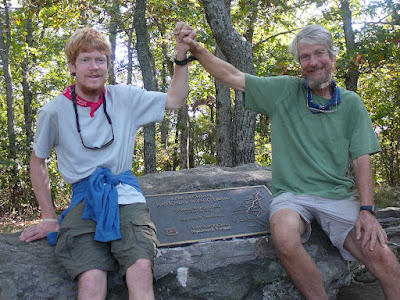
Day 128/155, Oct 15, Monday, Springer Mountain, GA
Miles From Springer: 0; Miles Hiked To Date: 2174.0; Miles Hiked Today: 14.9
We reached the AT plaque earlier than expected and had the mountain to ourselves. It seemed almost anti-climatic with just the two of us: no admiring crowd, no stunning views, no Pat. Where was Pat? Apparently, finding the parking lot for the trail up to Springer is easier said than done. She ended up driving down dirt roads, passing the ill marked parking area and finally getting directions from a friendly Park Ranger. We joked with her about us walking over 2000 miles and arriving ahead of her! On Springer, Brad and I congratulating each other, took a timed picture and generally couldn't think of anything profound or creative to say or do. Finally, a couple of guys came up and we got the conversation around to us and our accomplishment.
On the way back down to the parking lot, we ran into Lopsided. He had skipped some of the trail, losing so much time to illness.

Chester Creek at Base of Springer Mountain
So, here we are. I think we both feel pretty good about what we've done, but need time to really appreciate all we experienced. With so much to do over the next few weeks, that reflection time must come later. Many Thru Hikers talk about taking decompression time, but that's something we don't have the luxury of doing. I need to get back to the boat to get ready for our cruise south. Brad must pack up his things and head to Ann Arbor to live with his brother and sister-in-law while he looks for work.
One thing is certain, however. We couldn't have done it without each other. I know I couldn't have done it without Brad and I think he feels the same about me. The same can be said about Pat. Without her constant support, both as a booster and, more practically, as our personal Trail Angel, we would never have been successful. Many say thru-hiking the AT isn't what they expected. I agree. It was better.
To access a topological map showing the AT route and shelters click on the Appalachian Trail Map link in "Useful Links".
Day 124/151, Oct 11, Thursday, Hiawassee,
Miles From Springer: 66.6; Miles Hiked To Date: 2107.4; Miles Hiked Today: 30.9
Day 125/152, Oct 12, Friday, Deep Gap Shelter,
Miles From Springer: 63.1; MHTD: 2110.9 MMGTD: 3.5
We Saw No Sign (other than this one) of Aggressive Bears
Yesterday at noon, as we finished lunch atop Standing Indian Mountain, Brad suggested that we solve our resupply problem by hiking all the way to Hiawassee. That meant another 18 miles (we had already made 13 miles) before dark. Hiawassee, 10 miles from the trail, requiring a hitch from the trial head or finding a shuttle. We had little faith in the cell phone, being so remote. If we didn't get a ride, we'd have to stealth camp somewhere. Or, maybe hitchhike in the dark. He convinced me that we should try pointing out that we wanted to make Unicoi Gap for our promised Trail Angel feast. Getting to Hiawassee required averaging 3 miles an hour for 6 hours: faster than we've ever walked. Of course, if we could also stop at one of the shelters we'd pass on the way. Anyway, we set off at a blistering rate, moving downhill so fast that only our trekking poles kept us from falling forward. Fortunately, the trail was pretty well maintained.
Soon, we met a NOBO who had hiked Harpers Ferry to Katahdin last year. He recommended the Hiawassee Inn. While we talked to him, Brad tried his cell and to our surprise got a signal. We arranged to get picked up at 7:00, giving us some leeway. We kept up our fast pace and actually got to the trailhead by 6:00 pm.
The Inn is actually a regular hotel, not a hostel as we first thought. The owner let us use his van to drive to Daniels Steakhouse, an “all you can eat” buffet. To our surprise, we met up with Lopsided at the motel and he went with us. He had gotten sick (some kind of stomach thing) after leaving Fontana Dam. He left the trail and hitched a ride to a clinic. After being treated, he rested up at the Inn for a day and was heading out again on the twelfth (today).
We all went to dinner together around 7:30. When we returned to the Inn at 8:45 pm, the owner/manager came out of the office angrily and chastised us saying, “Usually, we hikers take one of our cars they just go to the restaurant, do their shopping and come back!” Surprised by his anger, I responded, “All we did was eat, we haven't even been to the grocery.” He repeated his accusation saying that we had violated a privilege. I was pretty tired and let my resentment color my response and edgily pointed out that we hadn't left until 7:30 and were only gone a little over an hour. He basically didn't accept that response. Finally, I said, “Look, if there was a time limit or deadline to return, you should have said something. We came into town to relax, get some decent food and resupply. If I had known we weren't going to be able to do that, I would have gone to the Holiday Inn (next door to the grocery and restaurant). He said that the office was kept open waiting for us, etc. He then said that he couldn't commit to getting us to the trail head tomorrow afternoon (something he had promised earlier). I asked if there was any other shuttle service. He finally told me “Sally or Joyce might be able to get you there.” He then called them and set it up.
Apparently, there's some kind of harvest festival in town starting the next day. The manager, it turned out, was stressed out, booked solid. Still,no one raised his voice, but the exchange definitely had an edge to it and I felt bad. It was so unlike every other experience we'd had on the trail.
I think some of these hiker hostel/service providers want to be both a business and an altruistic endeavor. The manager saw his lending us the van as a pure privilege – a generous offer that we abused. Actually, the only reason we stayed at his place was the fact that use of a vehicle was an advertised perk of staying there. The price difference between his place and the Holiday Inn is negligible. During our exchange, he made a point of telling us that “his man” had picked us up at the trail. I pointed out that we had paid him $20 plus a tip to do so for 20 minutes work. Anyway, the whole thing left a bad feeling between us.
This morning I woke up around 5:30, took a bath (my 3rd) and walked into “town” while Brad slept. They have a really nice coffee shop here. It had opened early, as I found out, to cater to a local high school soccer team. Along with great coffee, I got to hear the coach quote scripture, pray for victory, and somehow tie it altogether with the soccer adage, “when in doubt, kick it out.” It had something to do with sinful actions and putting the ball out of bounds. I didn't get it but the team listened attentively. All the while, the coach's 3 year old, bored and ignored, hung on his leg or lay between his feet as he paced before the group. Anyway, it was fun watching the kids interact. All the coffee house personnel knew all the local clientele. They clearly had more than a strictly business relationship with their customers.
Brad joined me as I was returning to the Inn. We went to the BBQ place (recommended by the clerk in the grocery store) for breakfast. It was most excellent. Two hours later, we went back for lunch.
We ended up only hiking about 4 miles, up to the next shelter, as planned. We head for Low Gap tomorrow passing through Unicoi Gap (GA 16) where we hope to meet up with Boomerang and his promised “serious trail magic.”
Day 126/153, Oct 13, Saturday, Low Gap Shelter,
Miles From Springer: 41.1; Miles Hiked To Date: 2132.9; Miles Hiked Today: 22
Well, Boomerang did not show. We arrived at the Unicoi gap intersection at 11:00, an hour earlier than expected. We waited until about 1:00. I really thought he would show up, given the detailed commitment he'd made. However, it would have been remarkable if he had, considering the level of effort required for a couple of strangers. Anyway, we used the time to read and relax, eat our usual lunch of tuna salad sandwiches finished with a candy bar. We had another perfect day for hiking. We saw no wildlife. In fact we haven't seen much since just south of Shenandoah. We made Low Gap Shelter around 4:00. Three guys from Florida were already there on a 4 day backpacking trip. Their first. They were were pretty beat. We got to bed early after deciding to start tomorrow at 5:00 (meaning that we get up at 4:00). That will give us a chance of making Hawk Mountain Shelter, just 7.6 miles from Springer. It also means a 33+mile hike. I'd better get some sleep.
Day 127/154, Oct 14, Sunday, Gouch Mountain Shelter
Miles From Springer: 14.9; Miles Hiked To Date: 2159.1; Miles Hiked Today: 26.2
Sunrise from Laurel Wolf Overlook
A beautiful starlit pre-dawn hike with a brilliant sunrise just as we arrived at Wolf Laurel Top (a bare rock face with an eastern exposure). We stopped to watch the sun come up over the mountains. Very nice. We arrived at the Neels Gap and the Walasi-Yi Center around 10:00. The Center hosts a well-stocked outfitter's store and hiker hostel. The AT runs right through an arch connecting the store with the hostel, making it the only building literally on the AT. For those heading north, the Center offers the first place to buy new gear, dump stuff that's too heavy or unnecessary and stock up on provisions. As a “service” to hikers, the store will go through your pack and tell you what you need and don't need. Of course, everything you need is available for purchase at their store. Still, it's a great place and one of the most complete outfitter's we've seen. We didn't need any gear, but we did consume our share of micro-wave cheeseburgers and chips for an early lunch. We tried to pick up something special to celebrate our pending arrival at Springer, but the pickings were pretty slim.
Sunrise from Laurel Wolf Overlook
We left Neels Gap by a little after 11:00, hoping to make it to Hawk Mountain. We hiked well but we would not have made it before dark. We stopped here, our original plan anyway. While at the Center we called Pat. She was just passing Harrisonburg, VA. I gave her our range for our ETA of between 9 and 2 tomorrow, depending on how far we got today. She'll meet us at the parking lot just before the AT terminus on Springer.
Passing through Walasi-Yi Center Portal at Neels Gap
There were a lot of day hikers out. We talked to several. One middle aged gentleman, Stan, was out on a day hike. We talked at length about Thru-Hiking and politics. He thinks Bush should be in prison. He's against the war in Iraq. He believes the government is systematically depriving us of our freedom. He and my brother, Ken, would have gotten along fine! As a retired long haul truck driver, owning his own rig, a Viet Nam veteran and a 59 year old southerner; Stan just doesn't fit the image of an anti-war type. Given his profile, you would guess conservative republican. Actually, we've seen the anti-Bush feeling throughout the South.
First View of Springer Mountain
Although disappointed that we didn't do the 30 miles we'd hoped for, still we have less than 15 miles to go!!! We're really excited and pretty proud of ourselves. I don't think either of us is fed up or exhausted. Nevertheless, we'll be glad to finish. Tomorrow we'll get an early start so we can have lunch with Pat. For now, we'll eat our last Ramen dinner and spend our last night in a shelter.
Day 128/155, Oct 15, Monday, Springer Mountain, GA
Miles From Springer: 0; Miles Hiked To Date: 2174.0; Miles Hiked Today: 14.9
We reached the AT plaque earlier than expected and had the mountain to ourselves. It seemed almost anti-climatic with just the two of us: no admiring crowd, no stunning views, no Pat. Where was Pat? Apparently, finding the parking lot for the trail up to Springer is easier said than done. She ended up driving down dirt roads, passing the ill marked parking area and finally getting directions from a friendly Park Ranger. We joked with her about us walking over 2000 miles and arriving ahead of her! On Springer, Brad and I congratulating each other, took a timed picture and generally couldn't think of anything profound or creative to say or do. Finally, a couple of guys came up and we got the conversation around to us and our accomplishment.
On the way back down to the parking lot, we ran into Lopsided. He had skipped some of the trail, losing so much time to illness.
Chester Creek at Base of Springer Mountain
So, here we are. I think we both feel pretty good about what we've done, but need time to really appreciate all we experienced. With so much to do over the next few weeks, that reflection time must come later. Many Thru Hikers talk about taking decompression time, but that's something we don't have the luxury of doing. I need to get back to the boat to get ready for our cruise south. Brad must pack up his things and head to Ann Arbor to live with his brother and sister-in-law while he looks for work.
One thing is certain, however. We couldn't have done it without each other. I know I couldn't have done it without Brad and I think he feels the same about me. The same can be said about Pat. Without her constant support, both as a booster and, more practically, as our personal Trail Angel, we would never have been successful. Many say thru-hiking the AT isn't what they expected. I agree. It was better.
Marching Through Maine
NOTE on format: Each journal entry begins with two 'day' entries (Day x/x). The first number reflects the sequential number of days actually hiked in part or in whole. The second, the sequential number of days elapsed, i.e., calendar days since beginning the hike including days off the trail. Next, the date and location of the journal entry. Entries accurately reflect those made while on the trail except for grammar or spelling corrections (I didn't carry a dictionary) and any original entries that made me look particularly stupid.
To access a topological map showing the AT route and shelters click on the Appalachian Trail Map link in "Useful Links".
Day 62/70, July 21, Saturday. Full Goose Shelter, ME.
Miles From Katahdin: 276.5; Miles Hiked To Date: 888.4; Miles Hiked Today: 9.6
We had planned to hike through Moohusuc Notch and stay at the Speck Pond Shelter but stopped short here at Full Goose Shelter. The Notch lies about 1 mile north and is considered the hardest 1 mile of the entire AT. The hike here was not easy, with steep climbs and descents over slippery rocks. Bare granite with no hand holds and a lot of mud.
Red, the section hiker, who stayed with us last night, hiked the same 10 miles yesterday in 11 hours. It took us only 7 but we weren't up for tackling the “toughest mile on the AT” after doing it.
Hellbender and Patrick, NOBO, have yet to arrive. We need to hike 14 miles a day to reach Pat in Rangeley on time. I am beginning to wonder (read, seriously doubt) we can do it. This presents a dilemma because there are few places that Pat can easily meet us. Without a cell phone we'll have to find a pay phone, a working pay phone. Andover, only 20 miles away, presents an option, but we'd get there too soon and end up losing some time. Also, it's 8 miles off the trail. We could hitch a ride, maybe, or find someone who could call the hiker's hostel there and get picked up. We'll figure something out. Good weather today. We got some nice views.
This morning just before we left the shelter, a young man came into camp. He asked how far it was to Gorham. He had hiked all night. He's a SOBO'r. He ran out of food yesterday and was walking non-stop to get to a resupply place. It's difficult to imagine someone hiking the trail we just completed in the dark. Supply points here are few and far between.

A middle aged couple joined us shortly after we arrived. They are headed south, section hiking. We gave them our maps for the remaining section they intend to hike as they had left theirs at home. I can't remember their trail names, some kind of cereal, 'Rice Krispies' and 'Wheaties'??? Another SOBO'r passed through, 'Happy'. He is hiking solo and knew the cereal couple. After he left, Wheaties told us that Happy had 'walked' from Indiana to Maine to start the trail!!!

Day 63/71, July 22, Sunday. Baldpate Lean-to, ME.
Miles From Katahdin: 264.5; Miles Hiked To Date: 900.4; Miles Hiked Today: 12
Perfect weather with sunshine and fair weather clouds paired with a challenging but interesting trail made for a glorious day for hiking!

Brad Descends Rebar Steps With Aplomb
The couple from Gentian Pond, Hellbender and Patrick, arrived early evening last night and stayed with us. Another guy arrived well after dark, but I didn't even know it until morning.
We took off around 6:10 am and met the challenge of Mooshusuc Notch. It's a jumble of house sized granite boulders wedged into a narrow gorge, creating an unbelievable obstacle course. You have to slide down bare faced granite and crawl through tunnels on your stomach. We had to remove our packs twice to get through. Adding to the experience, recently, maybe 2 weeks ago, a young but full grown moose fell to his death in the Notch right in the middle of the trail! He smells a bit worse that we do, but other than missing an eye, and being dead, the body is pretty much intact. I guess scavengers have not been able to get to him. The sight of this magnificent creature folded in among the rocks struck both Brad and I with sadness. This afternoon we learned from a NOBO'r that a couple of hikers entering the Notch from the south had startled the moose. He, the moose, ran into the Notch to escape, tried to climb up the steep side, slipped on the rocks and fell. They believe he may have broken a leg. The moose fell hard enough to be wedged between the rocks. Supposedly the rangers who were called arrived while the moose was still alive but left it there to starve. Apparently, the policy is to let nature takes it's course. That assumes that the backpackers are natural. Who knows? He'll be preserved there for some time due to the fact that even though it's July, he's lying on ice. Ice stays in the Notch all year round!
Brad and I carefully worked our way through the Notch, the moose serving as a pretty graphic caution. It took us 2 hours to get through that 1 mile. The hike itself wasn't hard, but you had to go very slowly. It was beautiful and challenging. The rest of the hike was the usual: steep climbs and great views. The good news is that trail was relatively dry, making traction much better.

Fallen Moose

Brad Negotiates "The Hardest Mile"

Tight Squeeze
Coming down Moohusuc Arm, we met 'GG' as she was climbing. 'GG' stands for “great grandma”. She's a 70 year old, solo hiker, about to finish the entire AT. She started her Thru Hike in 2005 but developed acute tendinitis in her ankle and had to leave the trail. She returned to the AT this year and made it to Mt. Washington, NOBO, when she fell on the rocks and injured the same ankle. She spent 3 days in emergency but was back on the trail picking up where she left off as soon as she was released. Her ankle still gave her problems. Her daughter, concerned, suggested that she leave the trail, that the Whites were too tough. She agreed and had her daughter take her up to Mt. Katahdin so that she could hike south! She said the trail from Mt. Katahdin is much less difficult and has given her ankle time to mend. So, she had nearly completed the Maine Section and seems to be going strong. She told us that she had forgotten her iodine tablets for purifying water. We had some as back up to the filter and gave her ours. In her gratitude, she gave us a jelly bean ("a" as in "one") each! Neither "G" stands for generous.
We lunched at Speck Pond, a beautiful shelter and campsite area, then continued on toward the Baldpate Lean-to.

Speck Pond
As we approached ME 26, coming off Old Speck, I began fantasizing about Trail Magic and how we hadn't seen any since Vermont. Lo and behold, as we approached the parking lot at the trailhead, a cooler appeared! It was loaded with Coke, Beer, snickers bars and ice!!! A note on the cooler invited Thru Hikers to help themselves! As we sat to enjoy our bounty, the Trail Angel responsible for this largess strolled up from the parking lot. He came to collect the cooler for the day (you can't leave food out overnight for fear of bears & and other critters getting into it). We had arrived just in time! He offered us anything else we wanted from the cooler and we each helped ourselves to another Coke and candy bar. The beer was tempting but I didn't think it conducive to the 2.5 mile uphill climb we had yet to walk.
As we were finishing, a group of hikers with their Bernise Mountain dog (I think that's what it was - a Newfoundland like dog but not tri-colored) came down the trail. They had just completed a 4 day hike that included the Notch. Imagine taking a dog through that place – a 100# dog at that! They said they would have left the dog at home had they known what the trail was like. In places they had to lower him down over the boulders. The woman had scratches all over her arms and legs from struggling with the dog. We found out that they live in Lee, NH! He's an engineering professor and they live on Jenkins Lane (just off Wednesday Hill Road and right next door to where we used to live)! They are originally from Germany. They were kind enough to take our trash including the four Coke bottles. They also gave us a large bag of trail snacks. What luck!!!
Tomorrow we need to decide what to do. We can make Rangeley if we hike 44.5 miles in 3 days. Brad's ankle is bothering him (seems like a repetitive motion type thing), so that's a factor. If we don't make Rangeley we have no easy way of either contacting or connecting with Pat. We could stop in Andover only 8 miles away and call her from there. Then we could arrange another pick up point (meaning a 16 mile detour to get to town and back to the trail) or just have her come and get us. The logistics of meeting her at some crossroad at some non-specific time is daunting. I told her I would call form Rangeley, thinking we would be there in plenty of time but that's not going to be the case. We won't get there until late afternoon, at best, and Rangeley is 9 miles off the trail! We will have to decide when we get to the Andover trail head tomorrow.

Day 65/80, Aug 2, Thursday. The Cabin, East Andover, ME.
Miles From Katahdin: 246.4; Miles Hiked To Date: 918.5; Miles Hiked Today: 10.1
A lot of catching up to do. We arrived at the trail head on East Hill (256.5 miles from K) near Andover around 2:00 pm on Monday the 23rd. After some discussion, we agreed to hitch into Andover and call Pat to pick us up. Andover lies 8 miles from the trail. East Hill Road, a narrow country lane, clearly saw little traffic, so we thought we were in for a long walk. Before we even started walking, a car approached. Brad motioned to the car to stop, but the driver took it as a friendly wave and waved back! We need to work on our hitchhiking skills!
We hadn't walked far when a car came up from the opposite direction, slowed to a stop next to us. The driver told us that the town was only 3 miles further. He had stopped only to tell us that we didn't have much farther to go! Well, we had only walked about 1 mile, while I thanked him, I was skeptical about his estimate. We have found that people in cars have a distorted perspective of distance. It was nice of him to stop, but it would have been nicer had he offered us a ride. Shortly, a pickup truck came along heading our direction. He stopped and offered us a ride. What a break!
The distance to town was every bit of 8 miles and we were extremely grateful for the ride. He dropped us in front of the General Store & Diner, just across the street and two doors down from the Andover Boarding House. We were really hungry, of course, but decided we'd better get checked into the hostel before we ate. Lucky that we did. The manager of the Boarding House was literally leaving for the day to take his boys fishing just as we walked up. We arranged for a private/double room ($50) – shared rooms were $20/person. He gave a quick tour and instructions before he left to go fishing. He said that if we leave, just leave the door open; if any hikers come, I was to put them in No. 3 and to let them know that the $20 rate was a discount of $5. Out he went, leaving the empty house to us!
We cleaned up (ourselves, not the house) and headed for the diner. We used the pay phone there to call Pat and explained our change of plans. She suggested that she leave right then to come and spend the night with us. What a girl!!! So, we had a nice meal at the Andover General Store (great double cheeseburgers), then returned to the Boarding House. We spent the rest of the afternoon reading, napping, doing our laundry, and watching movies from the House DVD collection. Pat arrived before dark and it was great seeing her again.
It was too soon to start south for the reunion. Brad and I didn't really want to go right there from the trail. Both of us were a little “burnt out” on trail life: no private space at night, day after day of hiking, bad food, etc. Also, I think we were a little home sick. We had a nice 5 hour ride home . Wednesday we just hung out after running a few errands.
We had an uneventful trip to the reunion in North Carolina. My brother, Ken, looked shocked when he saw me. My weight loss and beard made me almost unrecognizable. He said he would have walked right by me on the street. I think Brian and Liz were a little taken aback as well. The reunion was a success and we had a great time. Back in the car, I think we were all exhausted. Pat had had a headache for 3 days and she was getting sicker as we drove. Finally, we decided to get a room for the night just outside of Richmond, VA. Pat went right to bed and felt better when she woke several hours later. While she slept, we had a huge thunderstorm.
We got home Monday around 7:30 pm. Neither Brad nor I felt rested and ready to hit the trail. To get back to the AT we had a long drive ahead of us, then at least a 6 mile hike to the next shelter. We decided to wimp out again and took Tuesday off. Wednesday morning, we headed back to Maine. While we ate lunch at a nice Chinese restaurant, I suggested that rather than start hiking that afternoon as planned, we should get a motel and start fresh in the morning. My suggestion was prompted by the fact that the temperature was in the 80s and by the time we got to the trail it would be 3:00 pm, then, we'd have a 3-4 hour hike, mostly uphill. Brad agreed readily.
This morning, we were up and ready to go early. A short drive to Andover and a big breakfast at the diner and finally, back on the trail (East B Hill Road) around 8:00. The Trail over Moody Mountain proved to be very tough. The steepness, the heat, and our long break all took its toll. By early afternoon, we were beat. To our great surprise and good fortune, we met up with 'Plugger' again. A 65 year old retired systems analyst, we'd stayed with him at the Welcome Hike Hostel and last saw him on Mt Mooselauk. He was slack-packing today and had a car waiting for him at the next intersecting road. He had checked into the “Cabin”, a hiker hostel in East Andover. We had lunch with Plugger then headed off. Because we walked much faster, we got to the cross road well ahead of him (South Arm Road, 246.4 miles from K). With almost 10 miles to go to the next shelter, I suggested to Brad that we wait for Plugger and hop a ride with him to the Cabin. He agreed.

While we waited, we were joined by 2 NOBOs and 2 SOBOs – all of whom took a break. We exchanged the usual background and trail information. One hiker told of being shot at by someone in a passing pick up truck! Plugger showed up and we rode to the Cabin. The Cabin is a private home that has converted its lower level to accommodate hikers. It's a beautiful log cabin, built by her owners Margie and Earle Towne (aka, Honey & Bear). They were extremely friendly and made us feel very welcome. For $35 each, you get a bed, dinner and breakfast, plus shuttle service. The food was fantastic (BBQ'd chicken, corn on the cob, green beans, fresh from the garden salad, homemade rolls, mashed potatoes – plus homemade brownies & ice cream), served family style with Honey and Bear joining us at the table. Besides Plugger, 2 other hikers, Sam and Dwayne, were staying there. We ate well.
We could have eaten more if Plugger and the two of us hadn't stopped in at the Andover General Store & Diner on the way to the Cabin for cheeseburgers and fries! Plugger shared some interesting rumors with us while we ate. He said that a day hiker in the White Mountains had apparently committed suicide the day before by jumping from a cliff at Grafton Notch. Also, a man born without legs is hiking the entire AT on prosthetic legs!
While we ate, we met “Engine”, a disabled Desert Storm Vet. Plugger had run into him the day before. He told us that he had helped with the search for the man who committed suicide. He said that he had actually found the dead man's watch and car keys. According to him, this discovery led the Rangers to believe that the death was suicide and not an accident. He said that he found the keys and watch apparently placed at the edge of a cliff.
Day 66/81, Aug 3, Friday. Bemes Mtn Lean-To, ME
Miles From Katahdin: 237.7; Miles Hiked To Date: 927.2; Miles Hiked Today: 8.7
We were back on the trail by 6:45 am and had a great hike making the shelter at 11:30 am. We only hiked about 9 miles but it didn't make sense to go further. Tomorrow, we'll either walk to ME4 and hike into Rangeley or go to the shelter just north of there. That will put us in a good position to tackle Saddleback Mt. If we went on to the next shelter, we would have a long day with Saddleback at the end or a short day, one or the other. Thunderstorms are predicted this afternoon and we are starting to hear thunder. A number of people have shown up at the shelter. A brother and sister team from Winston-Salem, NC, a couple and a solo (all SOBOs). Only the brother and sister elected to stay in the shelter. She just graduated from a NC state college and he just graduated HS. They are hiking slowly, deliberately, and told us they had never backpacked before starting this trip. It rained most of their first 3 weeks! They started out doing 17-20 mile days-now they're doing 5-10. Plugger showed up around 5:00 pm. He left when we did, validating his trail name.

We all settled in around 8:00. Later that night, it started to rain harder and harder with tremendous lightening and thunder. Around 12:15 am a bolt of lightening struck so close that the thunder was nearly simultaneous. The flash was blinding. Brad thought the shelter had been hit! Plugger turned his light on to make sure everyone was okay. The rain continued till about 2 or 3:00 with hail pinging off the galvanized roof.

"Second Wind", Poet & Farm Worker, Among the Rocks
Day 67/82, Aug 4, Saturday. Rangeley Gull Pond Hostel, ME.
Miles From Katahdin: 220.0; Miles Hiked To Date: 944.9; Miles Hiked Today: 17.7
We walked about 17 miles today. Great weather and fairly easy hike. Since Rangeley is supposed to be the best trail town on the AT and since we won't have many chances to stop before the wilderness, we decided to hitch hike the 9 miles into town. It took over an hour to get a ride. Two guys from NH (Somersville) dropped us at the IGA just out of town. We waited so long for a ride (there were two other hikers ahead of us on the road hitchhiking as well), we tried to call for a shuttle. However, we could get no cell service. Brad walked up a long drive to a house to see if we could us their phone. While he was there, a 4X4 stopped! I asked them to wait and ran up to the house to get Brad. He was just about to make the call. We hustled back and jumped in. I don't think the driver appreciated waiting on a narrow country road for us but he didn't say anything.
After shopping, we walked into to town, ate an ice cream cone, found a nice restaurant, and finally, called the hostel for a pickup.

Walking the Ridgeline
The Gull Pond Hostel was great! Very comfortable and accommodating with a nice living room with VCR. Beautiful spot on the Pond with canoes and kayaks available. The manager/owner bought the place 20 years ago. There's quite a few people staying there, all going south. Brad went into town to pick up some snacks. We retired early.
Day 68/83, Aug 5, Sunday, Spaulding Mtn Lean-To, ME.
Miles From Katahdin: 201.3; Miles Hiked To Date: 963.6; Miles Hiked Today: 18.4
Day 69/84, Aug 6, Monday, White Wolf Inn, Stratton, ME.
Miles From Katahdin: 187.8; Miles Hiked To Date: 977.1; Miles Hiked Today: 13.5
Yesterday, we walked 18.4 miles from Rangeley to Spaulding Mtn lean to. We climbed several 4000+ peaks in the course of the day. Fantastic views and clear skies. Blueberries! Blueberries!!! And more blueberries!!! On the granite above the tree line the blueberries get a lot of sun and we helped ourselves to a couple of handfuls – delicious! Another bush, similar to Blueberries produced a blueberry like berry that tasted similar but not as sweet. We met a guy on “The Horn” (4041') who knew a lot about the plant life and shared his knowledge. We passed few hikers but did see a group of young women – maybe 15 in total who spoke French and only a little English. They tried to tell us that the trail below was muddy but didn't know the word for “muddy” and told us that there was “wet dirt”.
Our stretch goal was the “Summit House” on Sugarloaf Mtn, three miles beyond Spaulding Mtn Lean-to and .5 mile uphill off the trail. A privately owned structure, the derelict Summit House sits atop the mountain. It served as a ski lodge years ago. Closed now, the owners kindly allow hikers to stay there. The electric has been left on and the kitchen is supposedly furnished with a toaster oven, a hot plate and a radio. The lodge also offers a 360* view above the tree line. On clear day, you can see Mt. Washington and Mt. Katahdin, a month's worth of hiking in a glance! Brad and I really wanted to get there and spend the night, looking forward to the amenities and particularly a clear, unimpeded night sky. However, I just wasn't up to it. I felt bad because I could tell that Brad really wanted to go on. He didn't say anything however, when I suggested we stop for the night. Regardless, we had a wonderful day of hiking.
In addition to the great hike, we saw our first 'live' moose! He was a young bull with an impressive set of antlers. He wasn't particularly afraid of us. After staring at us for a while, he moved very gracefully; deeper into the woods. He remained in sight however. We were excited about seeing a moose finally. The trail is literally covered in many places with moose scat and there are almost as many moose tracks as human bootprints. We expected to see moose everyday but until today, no such luck.

Our stay at Rangeley was very relaxing. The hostel is a private residence that used to be a part of a large summer camp for rich kids. The owner, an elderly gentleman, who at first seemed a little strange but turned out to be a really nice guy. He shuttles guests to and from town as a part of the service. The hostel sits rights on a large pond with low hills surrounding it. A man who stayed at Hiker's Welcome in Glencliff stayed there as well. A group of young men went into town to check out Sarge's Pub. They returned around 2:30 am. I don't think they hiked the next day.
So, today's hike brought us to Stratton and the White Wolf Inn. We got our usual early start and took time to check out the Summit House. It was a little hazy but still the views were wonderful. The rest of the hike was challenging with three 4000'+ mountains and some steep descents. As we neared the summit of South Crocker Mt, it began to sprinkle. By 10:00, it was raining hard with strong winds. We had not had lunch before it began raining, so we ate a Snickers and started down toward ME 27 and Stratton as fast as we could.
We had been trying to decide whether to hitch into town or go on to the next shelter. The heavy rain had soaked us thoroughly. I definitely wanted to head into town. Brad agreed, primarily because he didn't want to spend another night in a shelter with snoring strangers. A middle aged fellow snored so loud last night that the floor of the shelter vibrated. “Second Wind” a solo NOBO, even though sleeping outside the shelter, provided a stereo accompaniment. So, the older guy would emit a loud, sleep depriving snore, echoed immediately by “Second Wind”. Synchronized snoring! It was a kind of like the “call and response” heard in certain churches.
As we came to the trail head the rain continued but not quite so hard. I was worried about getting a ride, being so wet and muddy but a pickup truck containing a woman and her early teenage son sat in the parking lot called me over to discuss trail conditions. They were waiting out the storm and trying to decide whether to start up the trail. After a brief discussion, she offered us a ride, dropping us at the White Wolf Inn after a wet, wind whipped ride in the back of her truck.
As puddles formed at our feet, we checked in, found our room and cleaned up. After a hot shower we spread our clothes out to dry, stuffed newspapers in our boots and headed out. The rain had slowed to a drizzle and we made a quick stop at the local grocery to buy alcohol for the stove. We ate dinner at the Inn and the food was fantastic. Great, hiker friendly people!
Day 70/85, Aug 7, Tuesday, Little Bigelow Lean-To ME.Miles From Katahdin: 172.5 Miles Hiked To Date: 992.4; Miles Hiked Today: 15.3
Another good day. No rain, beautiful scenery and a 15.3 mile day. We continue to hike well but are having equipment problems. Brad's boots are falling apart. Only a month old, a seam split. I called Pat and she is going to check with EMS (what would we do without her!). Also, Brad took a fall today, landed on his back and broke the water filter. I'm trying to fix it with GOOP. We'll see. Both boots and filter will be hard to replace. The next town, Caratunk has no outfitter. We have tablets as a a back up. Most of the Thru-Hikers don't filter or purify their water if it comes from a spring or small, high altitude stream. Tomorrow we pass 2 springs. Springs are pretty safe and we, too, have drunk directly from them. The longer term issue is more critical. Needing boots and water filters may be a good excuse to have Pat meet us in Munson.

The Little Bigelow shelter features “The Tubs”, a series of naturally formed pools fed by a nice waterfall on a fast moving brook. I eased myself into the deepest pool (about 5' deep) and stayed there all of about 10 minutes. The water is freezing cold. On a hot afternoon, it might feel great, but not today. I stayed in long enough for Brad to get a picture and to clean off a bit. Tomorrow, we head for Caratunk, 21.5 miles. We have to get there before 4:00 pm to catch the last “ferry” across the Kennebec River. The “free” ferry (gratuities accepted) crosses from the north side of the river when you raise a signal flag. The ferry, a canoe, comes only at certain times of the day. The challenge is to get there on time. No camping is permitted on the east side of the river. Fording the river, while possible, can be dangerous due to the periodic, unscheduled release of water from an upstream dam. Hikers have drowned in a 4' fast moving wall of water. The dam sounds a horn when water is released but if you're mid stream, you won't make to the other side before the water rises.

Day 71/86, Aug 8, Wed, Rivers & Trails Hostel, Caratunk, ME.
Miles From Katahdin: 151.2; Miles Hiked To Date: 1013.7; Miles Hiked Today: 21.3
We made it to the ferry with time to spare. The ferryman, a guy paddling a red canoe, operates from 9-11 am and from 2- 4 pm each day. We left the Little Bigelow lean-to at 5:50am and arrived at the ferry crossing on the Kennebec River at 1:45 pm! That's over 20 miles in about 8 hours (including a lunch break of 1 hour). Brad set the pace and the flat trail made for fairly easy going. Still a great effort. Second Wind had hiked on last night and camped 3 miles ahead of us. He started at the same time and we caught up with him around 9:00. He decided to walk with us (or, as he put it, “draft” off us) so that he could make better time. He was anxious to get to Caratunk to pick up a package at the post office. The Post Office closes at 5:00 and you have to cross the river to get to it. We walked 17 miles before 11:30am. Not that I'm bragging or anything! The trail, wet from a nearly continuous drizzle, brought us through a stately evergreen forest dotted with large ponds and the occasional waterfall. The rain stopped as we walked up to the ferry landing (basically a clear place on the shore). Dave, the ferryman, arrived on time on north bank. He ferried a couple over, then, Brad and I. The ferry service is under contract with the ATC. It began after a hiker tried to ford the river and drowned. The river has several dams on it. Released water from the dam increases the depth by 4' over the normal 4-6'. The 100 yard wide river innocently flows sedately suggesting more pond than river. But the sudden release of water, I guess, makes it treacherous. As we pushed off, Dave handed me a paddle to assist in the effort.

Brad Waiting for Ferry
Once on dry land, we walked the road to the hostel run by Steve Langley. He has run the hostel and ferry service for 20 years. He complained bitterly about tough economic times and vowed to get out of the business and get a “9-5” job. He told stories of hikers past. The Hostel operators have a communication network that passes on warnings about “troublesome” hikers. Those names get passed up and down this network. He told of one hiker, a young woman, named “Hellbender”. She apparently got so drunk at the annual Hiker Days in Harpers Ferry that she “pissed” on the floor of the ATC headquarters. We actually met this notorious libertine at Gentian Pond Shelter weeks ago. Steve shared a lot of other amusing stories about current Thru Hikers, but no one else that we knew. Most of the problems related to alcohol. Steve shuttled us up to the only restaurant in town, a great brew house attached to a lodge. We tried to call Pat 4 or 5 times but she's not picking up.
Steve asked if we needed anything. I told him about the problem with our water filter. He offered, and I accepted, the use of Steri-Pen left by previous hiker. He said that we could use it until we could find a replacement. The Steri-Pen kills the bad stuff by passing UV light through the water. We don't have the instruction manual, but I have seen someone else use one. How hard can it be? Steve said that we could just mail it back when we're through. These units retail for about $150! Wow, what a great offer. Steve doesn't know us from anyone, so it's amazing to me that he would trust us with such an expensive piece of equipment. The Steripen weighs only ounces , so I'm hopeful that it works.
So, showers, laundry, a great meal and a long hike then bed time at the old bunkhouse. Second Wind hopped out of a pick up shortly after we got back from dinner. He elected to sleep in his tent outside, so we get another 'snoreless' night.

Day 72/87, Aug 9, Thursday, Moxie Bald Lean-To, ME
Miles From Katahdin: 132.4; Miles Hiked To Date: 1032.5; Miles Hiked Today: 18.8
Today, we hiked from Caratunk and the Kennebec River to Bald Mountain Pond, passing Pleasant Pond and crossing Moxie Bald Mountain. A relatively easy hike. We left the hostel around 7:30 am with Steve shuttling us to the trail. We both slept well, having the hostel to ourselves. Second Wind took off around 6:00 am and we caught up with him around 10:00am. We found him talking to “Crystallis”, a middle aged section hiker, southbound to Stratton. She told us of being caught out in the big thunderstorm yesterday but remained in good spirits. Today, excellent weather. The Trail, although never reaching high altitudes, offered spectacular views. So many lakes and ponds! We found a bountiful supply of blueberries, a true bonus on an already wonderful day. I finally reached Pat this morning around 5:30 am. She will meet us in Monson with Brad's old boots. The water purifier, Steripen, seems to work well and is extremely light. This shelter, in spite of its ugly name, is probably the most beautiful setting we've seen. We are right on the pond. I took a “skinny dip” when we arrived: cleaning off a bit from our hike. The cool water was very refreshing. My swim was made more than a pleasure by the great need I had to clean up. Earlier, on top of Moxie Bald, I stepped between some boulders on the only trail available and found myself sinking up to my knees! I couldn't move! The narrow trail didn't allow room for Brad to help and there was nothing to grab onto to pull myself up. The suction on my boots was tremendous. The Trail at this point passed between boulders and dense vegetation. Black ooze covers the whole trail with no place to step around it. From past experience, I knew to test the surface for firmness and placed one foot on solid ground. The other foot gave way rapidly and I found myself in a comical but precarious position. I finally rolled a little to my right and grabbed the bushes, pulling myself up and out. I was covered with smelly black mud. This afternoon, the pond took care of the worse of it but I still had to scrape to get clean.

We made dinner tonight with stove top stuffing and freeze dried corn. It was pretty good. We ate by the pond. About halfway through our meal, a beaver swam to within 30 feet of us and consumed a sizable branch, snatched from shore. Neither of us had seen a beaver in the wild. We watched her for about ½ hour swimming back and forth.
Tomorrow, we reach Monson, last bastion of civilization before the 100 Mile Wilderness and Katahdin. Pat, hopefully, will be there to help us resupply.

Day 73/88, Aug 10, Friday, Monson, ME
Miles From Katahdin: 114.5; Miles Hiked To Date: 1050.4 Miles Hiked Today: 17.9

Day 74/90, Aug 12, Sunday, Long Pond Steam Lean-To, ME
Miles From Katahdin: 99.4; Miles Hiked To Date: 1065.5; Miles Hiked Today: 15.1
We made Monson on Friday by about noon and hitched into town. The only place we could find that served food was the Springhouse BBQ and it was superb! We stopped an older guy on the street wearing an ATC insignia on his shirt to ask about restaurants. He had no idea but he did know that the bar down the street sold 'shots' for 2 bucks! The Handbook states that the General Store serves food but they don't any longer. The owner of the store, however, thought that the Springhouse was open (the Handbook lists the hours of the Springhouse as 'sporadic'). He called “Miss Kim” to confirm and gave us directions.

We had a great meal: cheeseburgers, hand squeezed lemonade, French fries, potato salad. We arrived there about 2:00 pm and spent the afternoon eating and drinking lemonade waiting for Pat. We had blueberry pie and ice cream for desert.

Pat pulled up around 5:30 and on the advice of Kim we headed to Greenville – about 20 miles away. Brad's old boots proved to be in worse shape than we remembered and were unusable. We needed to find a place that had an outfitter and a motel. Greenville had one of the former and several of the later. We booked a room at a fantastic motel with great views of the mountains. Greenville, a little tourist town, sits on Moosehead Lake and thrives on tourist owned vacation homes and “return” visitors, as we were told by a local. Brad bought a new pair of boots and we ate very well. Once again, Pat made life easier by being there.
Back on the trail this morning around 8:00, we made this shelter around 2:30. Short of our goal but a decent effort. We need to really push to meet Pat in Baxter on Friday.
Last Thursday, Second Wind gave me a copy of his self published poems. We felt really honored.
We met some SOBO section hikers who had met on a Thru Hike several years ago. One man told his tale of how they met. Hiking solo, he was fording a waist deep, fast moving stream south of Katahdin when he lost his footing. Swept away by the current and strapped into his backpack, he floundered and sputtered down stream until he was grabbed by another hiker and pulled out of the river. The two have been friends ever since. This year's hike marked an anniversary of their meeting.

View of Long Pond
Day 75/91, Aug 13, Monday, Carl A. Newhall Lean-To, ME
Miles From Katahdin: 78.6; Miles Hiked To Date: 1086.3; Miles Hiked Today: 20.8
Beginning tomorrow, we need to really knock off some serious mileage to make our self imposed schedule. The good news is we have only one major mountain to cross before Katahdin. I think we can probably do some high 20s or even 30 mile days on the relatively flat terrain.
Day 76/92, Aug 14, Tuesday, Potaywadjo Spring Lean-To, ME
Miles From Katahdin: 48.3; Miles Hiked To Date: 1116.6; Miles Hiked Today: 30.3
We did 30.3 miles today, covering 4 peaks! Wow! After the peaks, the last until Katahdin, the trail was flat and dry. We exceeded our plan and are set up for a nice hike into Baxter (if we do another 30 mile day). Regardless, we will make our schedule to climb Katahdin on Friday. Today was gorgeous. Partly cloudy and 60-70* temperature. We had fog this morning as we climbed White Cap and, therefore, no views. On the other hand, we met up with a large trail maintenance crew. They were on their last day of their assignment. They greeted us with “Want some food?” They didn't want to have to carry everything out and had a tremendous amount left over. So, we made ourselves a couple of bagel/cream cheese sandwiches to eat on the way and two more to eat later, 2 apples each, and 8 cookies!!! That was our lunch.
We had a nice hike today and felt good about the miles made good. We aren't exhausted but certainly glad to stop. We saw and talked to several trail maintenance volunteers. They have done a terrific job here in ME. The best we've seen. I am surprised at the number of “recreation hikers” we've seen. The so-called 'Wilderness', has become pretty accessible with couple of forest roads. Still, it's very beautiful. A number of nice ponds and lakes. The woods are mostly evergreens and smell like Christmas.
Tomorrow, we may make it to Abol Campground just outside Baxter.
Day 77/93, Aug 15, Wed, Hurd Brook Lean-To, ME
Miles From Katahdin: 18.6; Miles Hiked To Date: 1146.3; Miles Hiked Today: 29.7
Day 78/94, Aug 16, Thur, The Birches, Baxter State Park, ME
Miles From Katahdin: 5.2; Miles Hiked To Date: 1159.7; Miles Hiked Today: 13.4
Yesterday we hiked another 30 miles but decided to stop at the Hurd Lean-To, 3.4 miles short of Abol. It was after 6:00 pm when we got to the shelter and we might not have made it to the campground before dark. Besides, the camp store closes at 7:00 and it would have been a close thing. A brother and sister team were at the shelter last night. They have been hiking together for 25 years. He has done almost all of the AT in sections. She has done great deal of the trail as well. This was the first of about a 30 day outing. They plan to get to Gorham. The woman, Nancy Wilson, fell off a trail bridge early in their hike toady. She hurt her left knee. I lent her one of my knee braces. She'll mail it back when she's done with it. She's from Damascus and offered us help, if needed, when we do the SOBO.

This is our week to do good deeds. Monday, at the Newman Shelter, two young women couldn't get their Coleman stove to light. So, Brad showed them how to use our wood stove. They were not very successful (knocking over the stove) so we let them use our alcohol stove. We first saw them as we were putting on our shoes after crossing East Branch River. They were about to cross without taking off their shoes when Brad yelled over that the water was deeper than it looked. That it would come over the top of their boots. They came on anyway and got their boots soaked! One of them later developed blisters as a result. When they went to put up their tent, one of the poles broke! They were still able to use it but all and all it was not a good start for a 4 day outing. On the other hand, it gave Brad a chance to be gallant and have some quality interaction with a couple of attractive young women.
Anyway, here we are at Baxter! We hiked down to the Abol Camp Store this morning just as they opened. The store doesn't carry much but we bought some milk, cake snacks, coffee and snacks for later. We really have everything we need for tomorrow and the rest of today. I did reach Pat on the pay phone. The pay phone is a cell connection. It worked even though we couldn't get a connection on our cell. It took 3 tries and 3 dollars to have a 3 minute conversation with Pat. Still, we were able to confirm our arrangements for tomorrow. She'll come to the Park and hang out until we've finished Katahdin.
Brad and I are both excited about finishing this leg of the hike and anxious to head south. We haven't decided whether or not to stop at home on the way back to Harper's Ferry. We may want to go to Bar Harbor. Another option, stop and visit with Second Wind, aka Mike, who invited us to stay with him in Bath, ME. He arrived here yesterday afternoon. He told us that he expected us to pass him somewhere in the Wilderness. He had a 1½ day head start and walked 20 miles a day. Still, he only got here ½ day ahead of us.

View of Katahdin
We did 2 - 30 mile days in a row. We both felt fine but I think that's pushing too hard. Today was relatively easy; a little over 13 miles. Beautiful walk along the river and streams, cascades and waterfalls. Really nice. This afternoon we're taking it easy; talking to other Thru and section hikers, reading and napping. The Park has a reserved campsite for long distance hikers (those who entered the Park after completing the 100 Mile Wilderness.

Katahdin Stream Falls
Day 79/95, Aug 17, Friday, The Birches, Baxter State Park, ME
Miles From Katahdin: 0; Miles Hiked To Date: 1164.9; Miles Hiked Today: 5.2

Fantastic walk today, early start, great climb to the summit and celebratory freeze dried double chocolate cheese cake. We started around 7:00 carrying only food, water and rain gear. The weather: mild and clear. The trail, well developed, passes nice waterfalls , quickly brings you above the tree line. The views from Katahdin differ from the rest of the AT by offering a 360* uninterrupted view, uncorrupted by power lines, cities or highways. The trail steepens as you near a sort of plateau just below the summit. Re-bar hand and footholds make the climb easier but in at least one place I had to boost Brad because his reach fell short of the nearest hand hold. Both Brad and I were surprised at the difficult nature of the climb. The approach at the base poised no difficulty. It follows Katahdin Stream much of the way and offers cascades and waterfalls of the clearest water you'll find anywhere. The trail up Katahdin is a bit of a challenge.
We reached the famous Katahdin sign noting Baxter Peak's 5,267 foot summit (the highest point in Maine ) around 10:30, a 3 ½ hour hike. We found a few people who had come up a different trail. Soon the peak buzzed with good spirits from a nearby crowd of hikers as they enjoyed the views and took pictures. One family forgot their camera, so I took a couple of pictures to email to them. We met up with 2 guys who had stayed at the Birches and we each took photos with each others cameras. The crowd reached about 15 or 20 by the time we were ready to descend. We contemplated hiking the 1 ½ mile Knife Edge, a razor thin ridge that descending from the summit in a crescent to the north. When I asked Brad if he wanted to hike the “Edge”, he replied, “I signed up to hike the AT. The Knife's Edge is not in the contract.”


View from Baxter Peak
We celebrated by mixing up the chocolate cheesecake. Unfortunately we forgot our spoons, so we just dipped our fingers into the plastic bag; messy but effective. We sat on the mountaintop enjoying the moment, watching clouds form below us and rise as the sun grew warmer. Our accomplishment brought on a warm sense of satisfaction rather than unrestrained joyfulness.
After about 3 hours, we headed back down. The weather remained excellent. Going down, however, proved harder than coming up. I lost my footing once while poised on a re-bar foothold. I fell hard on my shoulder. No serious harm done, but scary. At one point, Brad's foot wedged into a crevice and it too both of us to free it. A mile or so from the trail head, Pat came strolling up the trail! Hugs and kisses. Together we descended to the parking are. Pat presented each of us with a singe beautiful red rose. We then gathered our gear from the office and headed out of the park.

On Top of the World!
To access a topological map showing the AT route and shelters click on the Appalachian Trail Map link in "Useful Links".
Day 62/70, July 21, Saturday. Full Goose Shelter, ME.
Miles From Katahdin: 276.5; Miles Hiked To Date: 888.4; Miles Hiked Today: 9.6
We had planned to hike through Moohusuc Notch and stay at the Speck Pond Shelter but stopped short here at Full Goose Shelter. The Notch lies about 1 mile north and is considered the hardest 1 mile of the entire AT. The hike here was not easy, with steep climbs and descents over slippery rocks. Bare granite with no hand holds and a lot of mud.
Red, the section hiker, who stayed with us last night, hiked the same 10 miles yesterday in 11 hours. It took us only 7 but we weren't up for tackling the “toughest mile on the AT” after doing it.
Hellbender and Patrick, NOBO, have yet to arrive. We need to hike 14 miles a day to reach Pat in Rangeley on time. I am beginning to wonder (read, seriously doubt) we can do it. This presents a dilemma because there are few places that Pat can easily meet us. Without a cell phone we'll have to find a pay phone, a working pay phone. Andover, only 20 miles away, presents an option, but we'd get there too soon and end up losing some time. Also, it's 8 miles off the trail. We could hitch a ride, maybe, or find someone who could call the hiker's hostel there and get picked up. We'll figure something out. Good weather today. We got some nice views.
This morning just before we left the shelter, a young man came into camp. He asked how far it was to Gorham. He had hiked all night. He's a SOBO'r. He ran out of food yesterday and was walking non-stop to get to a resupply place. It's difficult to imagine someone hiking the trail we just completed in the dark. Supply points here are few and far between.
A middle aged couple joined us shortly after we arrived. They are headed south, section hiking. We gave them our maps for the remaining section they intend to hike as they had left theirs at home. I can't remember their trail names, some kind of cereal, 'Rice Krispies' and 'Wheaties'??? Another SOBO'r passed through, 'Happy'. He is hiking solo and knew the cereal couple. After he left, Wheaties told us that Happy had 'walked' from Indiana to Maine to start the trail!!!
Day 63/71, July 22, Sunday. Baldpate Lean-to, ME.
Miles From Katahdin: 264.5; Miles Hiked To Date: 900.4; Miles Hiked Today: 12
Perfect weather with sunshine and fair weather clouds paired with a challenging but interesting trail made for a glorious day for hiking!
Brad Descends Rebar Steps With Aplomb
The couple from Gentian Pond, Hellbender and Patrick, arrived early evening last night and stayed with us. Another guy arrived well after dark, but I didn't even know it until morning.
We took off around 6:10 am and met the challenge of Mooshusuc Notch. It's a jumble of house sized granite boulders wedged into a narrow gorge, creating an unbelievable obstacle course. You have to slide down bare faced granite and crawl through tunnels on your stomach. We had to remove our packs twice to get through. Adding to the experience, recently, maybe 2 weeks ago, a young but full grown moose fell to his death in the Notch right in the middle of the trail! He smells a bit worse that we do, but other than missing an eye, and being dead, the body is pretty much intact. I guess scavengers have not been able to get to him. The sight of this magnificent creature folded in among the rocks struck both Brad and I with sadness. This afternoon we learned from a NOBO'r that a couple of hikers entering the Notch from the south had startled the moose. He, the moose, ran into the Notch to escape, tried to climb up the steep side, slipped on the rocks and fell. They believe he may have broken a leg. The moose fell hard enough to be wedged between the rocks. Supposedly the rangers who were called arrived while the moose was still alive but left it there to starve. Apparently, the policy is to let nature takes it's course. That assumes that the backpackers are natural. Who knows? He'll be preserved there for some time due to the fact that even though it's July, he's lying on ice. Ice stays in the Notch all year round!
Brad and I carefully worked our way through the Notch, the moose serving as a pretty graphic caution. It took us 2 hours to get through that 1 mile. The hike itself wasn't hard, but you had to go very slowly. It was beautiful and challenging. The rest of the hike was the usual: steep climbs and great views. The good news is that trail was relatively dry, making traction much better.
Fallen Moose
Brad Negotiates "The Hardest Mile"
Tight Squeeze
Coming down Moohusuc Arm, we met 'GG' as she was climbing. 'GG' stands for “great grandma”. She's a 70 year old, solo hiker, about to finish the entire AT. She started her Thru Hike in 2005 but developed acute tendinitis in her ankle and had to leave the trail. She returned to the AT this year and made it to Mt. Washington, NOBO, when she fell on the rocks and injured the same ankle. She spent 3 days in emergency but was back on the trail picking up where she left off as soon as she was released. Her ankle still gave her problems. Her daughter, concerned, suggested that she leave the trail, that the Whites were too tough. She agreed and had her daughter take her up to Mt. Katahdin so that she could hike south! She said the trail from Mt. Katahdin is much less difficult and has given her ankle time to mend. So, she had nearly completed the Maine Section and seems to be going strong. She told us that she had forgotten her iodine tablets for purifying water. We had some as back up to the filter and gave her ours. In her gratitude, she gave us a jelly bean ("a" as in "one") each! Neither "G" stands for generous.
We lunched at Speck Pond, a beautiful shelter and campsite area, then continued on toward the Baldpate Lean-to.
Speck Pond
As we approached ME 26, coming off Old Speck, I began fantasizing about Trail Magic and how we hadn't seen any since Vermont. Lo and behold, as we approached the parking lot at the trailhead, a cooler appeared! It was loaded with Coke, Beer, snickers bars and ice!!! A note on the cooler invited Thru Hikers to help themselves! As we sat to enjoy our bounty, the Trail Angel responsible for this largess strolled up from the parking lot. He came to collect the cooler for the day (you can't leave food out overnight for fear of bears & and other critters getting into it). We had arrived just in time! He offered us anything else we wanted from the cooler and we each helped ourselves to another Coke and candy bar. The beer was tempting but I didn't think it conducive to the 2.5 mile uphill climb we had yet to walk.
As we were finishing, a group of hikers with their Bernise Mountain dog (I think that's what it was - a Newfoundland like dog but not tri-colored) came down the trail. They had just completed a 4 day hike that included the Notch. Imagine taking a dog through that place – a 100# dog at that! They said they would have left the dog at home had they known what the trail was like. In places they had to lower him down over the boulders. The woman had scratches all over her arms and legs from struggling with the dog. We found out that they live in Lee, NH! He's an engineering professor and they live on Jenkins Lane (just off Wednesday Hill Road and right next door to where we used to live)! They are originally from Germany. They were kind enough to take our trash including the four Coke bottles. They also gave us a large bag of trail snacks. What luck!!!
Tomorrow we need to decide what to do. We can make Rangeley if we hike 44.5 miles in 3 days. Brad's ankle is bothering him (seems like a repetitive motion type thing), so that's a factor. If we don't make Rangeley we have no easy way of either contacting or connecting with Pat. We could stop in Andover only 8 miles away and call her from there. Then we could arrange another pick up point (meaning a 16 mile detour to get to town and back to the trail) or just have her come and get us. The logistics of meeting her at some crossroad at some non-specific time is daunting. I told her I would call form Rangeley, thinking we would be there in plenty of time but that's not going to be the case. We won't get there until late afternoon, at best, and Rangeley is 9 miles off the trail! We will have to decide when we get to the Andover trail head tomorrow.
Day 65/80, Aug 2, Thursday. The Cabin, East Andover, ME.
Miles From Katahdin: 246.4; Miles Hiked To Date: 918.5; Miles Hiked Today: 10.1
A lot of catching up to do. We arrived at the trail head on East Hill (256.5 miles from K) near Andover around 2:00 pm on Monday the 23rd. After some discussion, we agreed to hitch into Andover and call Pat to pick us up. Andover lies 8 miles from the trail. East Hill Road, a narrow country lane, clearly saw little traffic, so we thought we were in for a long walk. Before we even started walking, a car approached. Brad motioned to the car to stop, but the driver took it as a friendly wave and waved back! We need to work on our hitchhiking skills!
We hadn't walked far when a car came up from the opposite direction, slowed to a stop next to us. The driver told us that the town was only 3 miles further. He had stopped only to tell us that we didn't have much farther to go! Well, we had only walked about 1 mile, while I thanked him, I was skeptical about his estimate. We have found that people in cars have a distorted perspective of distance. It was nice of him to stop, but it would have been nicer had he offered us a ride. Shortly, a pickup truck came along heading our direction. He stopped and offered us a ride. What a break!
The distance to town was every bit of 8 miles and we were extremely grateful for the ride. He dropped us in front of the General Store & Diner, just across the street and two doors down from the Andover Boarding House. We were really hungry, of course, but decided we'd better get checked into the hostel before we ate. Lucky that we did. The manager of the Boarding House was literally leaving for the day to take his boys fishing just as we walked up. We arranged for a private/double room ($50) – shared rooms were $20/person. He gave a quick tour and instructions before he left to go fishing. He said that if we leave, just leave the door open; if any hikers come, I was to put them in No. 3 and to let them know that the $20 rate was a discount of $5. Out he went, leaving the empty house to us!
We cleaned up (ourselves, not the house) and headed for the diner. We used the pay phone there to call Pat and explained our change of plans. She suggested that she leave right then to come and spend the night with us. What a girl!!! So, we had a nice meal at the Andover General Store (great double cheeseburgers), then returned to the Boarding House. We spent the rest of the afternoon reading, napping, doing our laundry, and watching movies from the House DVD collection. Pat arrived before dark and it was great seeing her again.
It was too soon to start south for the reunion. Brad and I didn't really want to go right there from the trail. Both of us were a little “burnt out” on trail life: no private space at night, day after day of hiking, bad food, etc. Also, I think we were a little home sick. We had a nice 5 hour ride home . Wednesday we just hung out after running a few errands.
We had an uneventful trip to the reunion in North Carolina. My brother, Ken, looked shocked when he saw me. My weight loss and beard made me almost unrecognizable. He said he would have walked right by me on the street. I think Brian and Liz were a little taken aback as well. The reunion was a success and we had a great time. Back in the car, I think we were all exhausted. Pat had had a headache for 3 days and she was getting sicker as we drove. Finally, we decided to get a room for the night just outside of Richmond, VA. Pat went right to bed and felt better when she woke several hours later. While she slept, we had a huge thunderstorm.
We got home Monday around 7:30 pm. Neither Brad nor I felt rested and ready to hit the trail. To get back to the AT we had a long drive ahead of us, then at least a 6 mile hike to the next shelter. We decided to wimp out again and took Tuesday off. Wednesday morning, we headed back to Maine. While we ate lunch at a nice Chinese restaurant, I suggested that rather than start hiking that afternoon as planned, we should get a motel and start fresh in the morning. My suggestion was prompted by the fact that the temperature was in the 80s and by the time we got to the trail it would be 3:00 pm, then, we'd have a 3-4 hour hike, mostly uphill. Brad agreed readily.
This morning, we were up and ready to go early. A short drive to Andover and a big breakfast at the diner and finally, back on the trail (East B Hill Road) around 8:00. The Trail over Moody Mountain proved to be very tough. The steepness, the heat, and our long break all took its toll. By early afternoon, we were beat. To our great surprise and good fortune, we met up with 'Plugger' again. A 65 year old retired systems analyst, we'd stayed with him at the Welcome Hike Hostel and last saw him on Mt Mooselauk. He was slack-packing today and had a car waiting for him at the next intersecting road. He had checked into the “Cabin”, a hiker hostel in East Andover. We had lunch with Plugger then headed off. Because we walked much faster, we got to the cross road well ahead of him (South Arm Road, 246.4 miles from K). With almost 10 miles to go to the next shelter, I suggested to Brad that we wait for Plugger and hop a ride with him to the Cabin. He agreed.
While we waited, we were joined by 2 NOBOs and 2 SOBOs – all of whom took a break. We exchanged the usual background and trail information. One hiker told of being shot at by someone in a passing pick up truck! Plugger showed up and we rode to the Cabin. The Cabin is a private home that has converted its lower level to accommodate hikers. It's a beautiful log cabin, built by her owners Margie and Earle Towne (aka, Honey & Bear). They were extremely friendly and made us feel very welcome. For $35 each, you get a bed, dinner and breakfast, plus shuttle service. The food was fantastic (BBQ'd chicken, corn on the cob, green beans, fresh from the garden salad, homemade rolls, mashed potatoes – plus homemade brownies & ice cream), served family style with Honey and Bear joining us at the table. Besides Plugger, 2 other hikers, Sam and Dwayne, were staying there. We ate well.
We could have eaten more if Plugger and the two of us hadn't stopped in at the Andover General Store & Diner on the way to the Cabin for cheeseburgers and fries! Plugger shared some interesting rumors with us while we ate. He said that a day hiker in the White Mountains had apparently committed suicide the day before by jumping from a cliff at Grafton Notch. Also, a man born without legs is hiking the entire AT on prosthetic legs!
While we ate, we met “Engine”, a disabled Desert Storm Vet. Plugger had run into him the day before. He told us that he had helped with the search for the man who committed suicide. He said that he had actually found the dead man's watch and car keys. According to him, this discovery led the Rangers to believe that the death was suicide and not an accident. He said that he found the keys and watch apparently placed at the edge of a cliff.
Day 66/81, Aug 3, Friday. Bemes Mtn Lean-To, ME
Miles From Katahdin: 237.7; Miles Hiked To Date: 927.2; Miles Hiked Today: 8.7
We were back on the trail by 6:45 am and had a great hike making the shelter at 11:30 am. We only hiked about 9 miles but it didn't make sense to go further. Tomorrow, we'll either walk to ME4 and hike into Rangeley or go to the shelter just north of there. That will put us in a good position to tackle Saddleback Mt. If we went on to the next shelter, we would have a long day with Saddleback at the end or a short day, one or the other. Thunderstorms are predicted this afternoon and we are starting to hear thunder. A number of people have shown up at the shelter. A brother and sister team from Winston-Salem, NC, a couple and a solo (all SOBOs). Only the brother and sister elected to stay in the shelter. She just graduated from a NC state college and he just graduated HS. They are hiking slowly, deliberately, and told us they had never backpacked before starting this trip. It rained most of their first 3 weeks! They started out doing 17-20 mile days-now they're doing 5-10. Plugger showed up around 5:00 pm. He left when we did, validating his trail name.
We all settled in around 8:00. Later that night, it started to rain harder and harder with tremendous lightening and thunder. Around 12:15 am a bolt of lightening struck so close that the thunder was nearly simultaneous. The flash was blinding. Brad thought the shelter had been hit! Plugger turned his light on to make sure everyone was okay. The rain continued till about 2 or 3:00 with hail pinging off the galvanized roof.
"Second Wind", Poet & Farm Worker, Among the Rocks
Day 67/82, Aug 4, Saturday. Rangeley Gull Pond Hostel, ME.
Miles From Katahdin: 220.0; Miles Hiked To Date: 944.9; Miles Hiked Today: 17.7
We walked about 17 miles today. Great weather and fairly easy hike. Since Rangeley is supposed to be the best trail town on the AT and since we won't have many chances to stop before the wilderness, we decided to hitch hike the 9 miles into town. It took over an hour to get a ride. Two guys from NH (Somersville) dropped us at the IGA just out of town. We waited so long for a ride (there were two other hikers ahead of us on the road hitchhiking as well), we tried to call for a shuttle. However, we could get no cell service. Brad walked up a long drive to a house to see if we could us their phone. While he was there, a 4X4 stopped! I asked them to wait and ran up to the house to get Brad. He was just about to make the call. We hustled back and jumped in. I don't think the driver appreciated waiting on a narrow country road for us but he didn't say anything.
After shopping, we walked into to town, ate an ice cream cone, found a nice restaurant, and finally, called the hostel for a pickup.
Walking the Ridgeline
The Gull Pond Hostel was great! Very comfortable and accommodating with a nice living room with VCR. Beautiful spot on the Pond with canoes and kayaks available. The manager/owner bought the place 20 years ago. There's quite a few people staying there, all going south. Brad went into town to pick up some snacks. We retired early.
Day 68/83, Aug 5, Sunday, Spaulding Mtn Lean-To, ME.
Miles From Katahdin: 201.3; Miles Hiked To Date: 963.6; Miles Hiked Today: 18.4
Day 69/84, Aug 6, Monday, White Wolf Inn, Stratton, ME.
Miles From Katahdin: 187.8; Miles Hiked To Date: 977.1; Miles Hiked Today: 13.5
Yesterday, we walked 18.4 miles from Rangeley to Spaulding Mtn lean to. We climbed several 4000+ peaks in the course of the day. Fantastic views and clear skies. Blueberries! Blueberries!!! And more blueberries!!! On the granite above the tree line the blueberries get a lot of sun and we helped ourselves to a couple of handfuls – delicious! Another bush, similar to Blueberries produced a blueberry like berry that tasted similar but not as sweet. We met a guy on “The Horn” (4041') who knew a lot about the plant life and shared his knowledge. We passed few hikers but did see a group of young women – maybe 15 in total who spoke French and only a little English. They tried to tell us that the trail below was muddy but didn't know the word for “muddy” and told us that there was “wet dirt”.
Our stretch goal was the “Summit House” on Sugarloaf Mtn, three miles beyond Spaulding Mtn Lean-to and .5 mile uphill off the trail. A privately owned structure, the derelict Summit House sits atop the mountain. It served as a ski lodge years ago. Closed now, the owners kindly allow hikers to stay there. The electric has been left on and the kitchen is supposedly furnished with a toaster oven, a hot plate and a radio. The lodge also offers a 360* view above the tree line. On clear day, you can see Mt. Washington and Mt. Katahdin, a month's worth of hiking in a glance! Brad and I really wanted to get there and spend the night, looking forward to the amenities and particularly a clear, unimpeded night sky. However, I just wasn't up to it. I felt bad because I could tell that Brad really wanted to go on. He didn't say anything however, when I suggested we stop for the night. Regardless, we had a wonderful day of hiking.
In addition to the great hike, we saw our first 'live' moose! He was a young bull with an impressive set of antlers. He wasn't particularly afraid of us. After staring at us for a while, he moved very gracefully; deeper into the woods. He remained in sight however. We were excited about seeing a moose finally. The trail is literally covered in many places with moose scat and there are almost as many moose tracks as human bootprints. We expected to see moose everyday but until today, no such luck.
Our stay at Rangeley was very relaxing. The hostel is a private residence that used to be a part of a large summer camp for rich kids. The owner, an elderly gentleman, who at first seemed a little strange but turned out to be a really nice guy. He shuttles guests to and from town as a part of the service. The hostel sits rights on a large pond with low hills surrounding it. A man who stayed at Hiker's Welcome in Glencliff stayed there as well. A group of young men went into town to check out Sarge's Pub. They returned around 2:30 am. I don't think they hiked the next day.
So, today's hike brought us to Stratton and the White Wolf Inn. We got our usual early start and took time to check out the Summit House. It was a little hazy but still the views were wonderful. The rest of the hike was challenging with three 4000'+ mountains and some steep descents. As we neared the summit of South Crocker Mt, it began to sprinkle. By 10:00, it was raining hard with strong winds. We had not had lunch before it began raining, so we ate a Snickers and started down toward ME 27 and Stratton as fast as we could.
We had been trying to decide whether to hitch into town or go on to the next shelter. The heavy rain had soaked us thoroughly. I definitely wanted to head into town. Brad agreed, primarily because he didn't want to spend another night in a shelter with snoring strangers. A middle aged fellow snored so loud last night that the floor of the shelter vibrated. “Second Wind” a solo NOBO, even though sleeping outside the shelter, provided a stereo accompaniment. So, the older guy would emit a loud, sleep depriving snore, echoed immediately by “Second Wind”. Synchronized snoring! It was a kind of like the “call and response” heard in certain churches.
As we came to the trail head the rain continued but not quite so hard. I was worried about getting a ride, being so wet and muddy but a pickup truck containing a woman and her early teenage son sat in the parking lot called me over to discuss trail conditions. They were waiting out the storm and trying to decide whether to start up the trail. After a brief discussion, she offered us a ride, dropping us at the White Wolf Inn after a wet, wind whipped ride in the back of her truck.
As puddles formed at our feet, we checked in, found our room and cleaned up. After a hot shower we spread our clothes out to dry, stuffed newspapers in our boots and headed out. The rain had slowed to a drizzle and we made a quick stop at the local grocery to buy alcohol for the stove. We ate dinner at the Inn and the food was fantastic. Great, hiker friendly people!
Day 70/85, Aug 7, Tuesday, Little Bigelow Lean-To ME.Miles From Katahdin: 172.5 Miles Hiked To Date: 992.4; Miles Hiked Today: 15.3
Another good day. No rain, beautiful scenery and a 15.3 mile day. We continue to hike well but are having equipment problems. Brad's boots are falling apart. Only a month old, a seam split. I called Pat and she is going to check with EMS (what would we do without her!). Also, Brad took a fall today, landed on his back and broke the water filter. I'm trying to fix it with GOOP. We'll see. Both boots and filter will be hard to replace. The next town, Caratunk has no outfitter. We have tablets as a a back up. Most of the Thru-Hikers don't filter or purify their water if it comes from a spring or small, high altitude stream. Tomorrow we pass 2 springs. Springs are pretty safe and we, too, have drunk directly from them. The longer term issue is more critical. Needing boots and water filters may be a good excuse to have Pat meet us in Munson.
The Little Bigelow shelter features “The Tubs”, a series of naturally formed pools fed by a nice waterfall on a fast moving brook. I eased myself into the deepest pool (about 5' deep) and stayed there all of about 10 minutes. The water is freezing cold. On a hot afternoon, it might feel great, but not today. I stayed in long enough for Brad to get a picture and to clean off a bit. Tomorrow, we head for Caratunk, 21.5 miles. We have to get there before 4:00 pm to catch the last “ferry” across the Kennebec River. The “free” ferry (gratuities accepted) crosses from the north side of the river when you raise a signal flag. The ferry, a canoe, comes only at certain times of the day. The challenge is to get there on time. No camping is permitted on the east side of the river. Fording the river, while possible, can be dangerous due to the periodic, unscheduled release of water from an upstream dam. Hikers have drowned in a 4' fast moving wall of water. The dam sounds a horn when water is released but if you're mid stream, you won't make to the other side before the water rises.
Day 71/86, Aug 8, Wed, Rivers & Trails Hostel, Caratunk, ME.
Miles From Katahdin: 151.2; Miles Hiked To Date: 1013.7; Miles Hiked Today: 21.3
We made it to the ferry with time to spare. The ferryman, a guy paddling a red canoe, operates from 9-11 am and from 2- 4 pm each day. We left the Little Bigelow lean-to at 5:50am and arrived at the ferry crossing on the Kennebec River at 1:45 pm! That's over 20 miles in about 8 hours (including a lunch break of 1 hour). Brad set the pace and the flat trail made for fairly easy going. Still a great effort. Second Wind had hiked on last night and camped 3 miles ahead of us. He started at the same time and we caught up with him around 9:00. He decided to walk with us (or, as he put it, “draft” off us) so that he could make better time. He was anxious to get to Caratunk to pick up a package at the post office. The Post Office closes at 5:00 and you have to cross the river to get to it. We walked 17 miles before 11:30am. Not that I'm bragging or anything! The trail, wet from a nearly continuous drizzle, brought us through a stately evergreen forest dotted with large ponds and the occasional waterfall. The rain stopped as we walked up to the ferry landing (basically a clear place on the shore). Dave, the ferryman, arrived on time on north bank. He ferried a couple over, then, Brad and I. The ferry service is under contract with the ATC. It began after a hiker tried to ford the river and drowned. The river has several dams on it. Released water from the dam increases the depth by 4' over the normal 4-6'. The 100 yard wide river innocently flows sedately suggesting more pond than river. But the sudden release of water, I guess, makes it treacherous. As we pushed off, Dave handed me a paddle to assist in the effort.
Brad Waiting for Ferry
Once on dry land, we walked the road to the hostel run by Steve Langley. He has run the hostel and ferry service for 20 years. He complained bitterly about tough economic times and vowed to get out of the business and get a “9-5” job. He told stories of hikers past. The Hostel operators have a communication network that passes on warnings about “troublesome” hikers. Those names get passed up and down this network. He told of one hiker, a young woman, named “Hellbender”. She apparently got so drunk at the annual Hiker Days in Harpers Ferry that she “pissed” on the floor of the ATC headquarters. We actually met this notorious libertine at Gentian Pond Shelter weeks ago. Steve shared a lot of other amusing stories about current Thru Hikers, but no one else that we knew. Most of the problems related to alcohol. Steve shuttled us up to the only restaurant in town, a great brew house attached to a lodge. We tried to call Pat 4 or 5 times but she's not picking up.
Steve asked if we needed anything. I told him about the problem with our water filter. He offered, and I accepted, the use of Steri-Pen left by previous hiker. He said that we could use it until we could find a replacement. The Steri-Pen kills the bad stuff by passing UV light through the water. We don't have the instruction manual, but I have seen someone else use one. How hard can it be? Steve said that we could just mail it back when we're through. These units retail for about $150! Wow, what a great offer. Steve doesn't know us from anyone, so it's amazing to me that he would trust us with such an expensive piece of equipment. The Steripen weighs only ounces , so I'm hopeful that it works.
So, showers, laundry, a great meal and a long hike then bed time at the old bunkhouse. Second Wind hopped out of a pick up shortly after we got back from dinner. He elected to sleep in his tent outside, so we get another 'snoreless' night.
Day 72/87, Aug 9, Thursday, Moxie Bald Lean-To, ME
Miles From Katahdin: 132.4; Miles Hiked To Date: 1032.5; Miles Hiked Today: 18.8
Today, we hiked from Caratunk and the Kennebec River to Bald Mountain Pond, passing Pleasant Pond and crossing Moxie Bald Mountain. A relatively easy hike. We left the hostel around 7:30 am with Steve shuttling us to the trail. We both slept well, having the hostel to ourselves. Second Wind took off around 6:00 am and we caught up with him around 10:00am. We found him talking to “Crystallis”, a middle aged section hiker, southbound to Stratton. She told us of being caught out in the big thunderstorm yesterday but remained in good spirits. Today, excellent weather. The Trail, although never reaching high altitudes, offered spectacular views. So many lakes and ponds! We found a bountiful supply of blueberries, a true bonus on an already wonderful day. I finally reached Pat this morning around 5:30 am. She will meet us in Monson with Brad's old boots. The water purifier, Steripen, seems to work well and is extremely light. This shelter, in spite of its ugly name, is probably the most beautiful setting we've seen. We are right on the pond. I took a “skinny dip” when we arrived: cleaning off a bit from our hike. The cool water was very refreshing. My swim was made more than a pleasure by the great need I had to clean up. Earlier, on top of Moxie Bald, I stepped between some boulders on the only trail available and found myself sinking up to my knees! I couldn't move! The narrow trail didn't allow room for Brad to help and there was nothing to grab onto to pull myself up. The suction on my boots was tremendous. The Trail at this point passed between boulders and dense vegetation. Black ooze covers the whole trail with no place to step around it. From past experience, I knew to test the surface for firmness and placed one foot on solid ground. The other foot gave way rapidly and I found myself in a comical but precarious position. I finally rolled a little to my right and grabbed the bushes, pulling myself up and out. I was covered with smelly black mud. This afternoon, the pond took care of the worse of it but I still had to scrape to get clean.
We made dinner tonight with stove top stuffing and freeze dried corn. It was pretty good. We ate by the pond. About halfway through our meal, a beaver swam to within 30 feet of us and consumed a sizable branch, snatched from shore. Neither of us had seen a beaver in the wild. We watched her for about ½ hour swimming back and forth.
Tomorrow, we reach Monson, last bastion of civilization before the 100 Mile Wilderness and Katahdin. Pat, hopefully, will be there to help us resupply.
Day 73/88, Aug 10, Friday, Monson, ME
Miles From Katahdin: 114.5; Miles Hiked To Date: 1050.4 Miles Hiked Today: 17.9
Day 74/90, Aug 12, Sunday, Long Pond Steam Lean-To, ME
Miles From Katahdin: 99.4; Miles Hiked To Date: 1065.5; Miles Hiked Today: 15.1
We made Monson on Friday by about noon and hitched into town. The only place we could find that served food was the Springhouse BBQ and it was superb! We stopped an older guy on the street wearing an ATC insignia on his shirt to ask about restaurants. He had no idea but he did know that the bar down the street sold 'shots' for 2 bucks! The Handbook states that the General Store serves food but they don't any longer. The owner of the store, however, thought that the Springhouse was open (the Handbook lists the hours of the Springhouse as 'sporadic'). He called “Miss Kim” to confirm and gave us directions.
We had a great meal: cheeseburgers, hand squeezed lemonade, French fries, potato salad. We arrived there about 2:00 pm and spent the afternoon eating and drinking lemonade waiting for Pat. We had blueberry pie and ice cream for desert.
Pat pulled up around 5:30 and on the advice of Kim we headed to Greenville – about 20 miles away. Brad's old boots proved to be in worse shape than we remembered and were unusable. We needed to find a place that had an outfitter and a motel. Greenville had one of the former and several of the later. We booked a room at a fantastic motel with great views of the mountains. Greenville, a little tourist town, sits on Moosehead Lake and thrives on tourist owned vacation homes and “return” visitors, as we were told by a local. Brad bought a new pair of boots and we ate very well. Once again, Pat made life easier by being there.
Back on the trail this morning around 8:00, we made this shelter around 2:30. Short of our goal but a decent effort. We need to really push to meet Pat in Baxter on Friday.
Last Thursday, Second Wind gave me a copy of his self published poems. We felt really honored.
We met some SOBO section hikers who had met on a Thru Hike several years ago. One man told his tale of how they met. Hiking solo, he was fording a waist deep, fast moving stream south of Katahdin when he lost his footing. Swept away by the current and strapped into his backpack, he floundered and sputtered down stream until he was grabbed by another hiker and pulled out of the river. The two have been friends ever since. This year's hike marked an anniversary of their meeting.
View of Long Pond
Day 75/91, Aug 13, Monday, Carl A. Newhall Lean-To, ME
Miles From Katahdin: 78.6; Miles Hiked To Date: 1086.3; Miles Hiked Today: 20.8
Beginning tomorrow, we need to really knock off some serious mileage to make our self imposed schedule. The good news is we have only one major mountain to cross before Katahdin. I think we can probably do some high 20s or even 30 mile days on the relatively flat terrain.
Day 76/92, Aug 14, Tuesday, Potaywadjo Spring Lean-To, ME
Miles From Katahdin: 48.3; Miles Hiked To Date: 1116.6; Miles Hiked Today: 30.3
We did 30.3 miles today, covering 4 peaks! Wow! After the peaks, the last until Katahdin, the trail was flat and dry. We exceeded our plan and are set up for a nice hike into Baxter (if we do another 30 mile day). Regardless, we will make our schedule to climb Katahdin on Friday. Today was gorgeous. Partly cloudy and 60-70* temperature. We had fog this morning as we climbed White Cap and, therefore, no views. On the other hand, we met up with a large trail maintenance crew. They were on their last day of their assignment. They greeted us with “Want some food?” They didn't want to have to carry everything out and had a tremendous amount left over. So, we made ourselves a couple of bagel/cream cheese sandwiches to eat on the way and two more to eat later, 2 apples each, and 8 cookies!!! That was our lunch.
We had a nice hike today and felt good about the miles made good. We aren't exhausted but certainly glad to stop. We saw and talked to several trail maintenance volunteers. They have done a terrific job here in ME. The best we've seen. I am surprised at the number of “recreation hikers” we've seen. The so-called 'Wilderness', has become pretty accessible with couple of forest roads. Still, it's very beautiful. A number of nice ponds and lakes. The woods are mostly evergreens and smell like Christmas.
Tomorrow, we may make it to Abol Campground just outside Baxter.
Day 77/93, Aug 15, Wed, Hurd Brook Lean-To, ME
Miles From Katahdin: 18.6; Miles Hiked To Date: 1146.3; Miles Hiked Today: 29.7
Day 78/94, Aug 16, Thur, The Birches, Baxter State Park, ME
Miles From Katahdin: 5.2; Miles Hiked To Date: 1159.7; Miles Hiked Today: 13.4
Yesterday we hiked another 30 miles but decided to stop at the Hurd Lean-To, 3.4 miles short of Abol. It was after 6:00 pm when we got to the shelter and we might not have made it to the campground before dark. Besides, the camp store closes at 7:00 and it would have been a close thing. A brother and sister team were at the shelter last night. They have been hiking together for 25 years. He has done almost all of the AT in sections. She has done great deal of the trail as well. This was the first of about a 30 day outing. They plan to get to Gorham. The woman, Nancy Wilson, fell off a trail bridge early in their hike toady. She hurt her left knee. I lent her one of my knee braces. She'll mail it back when she's done with it. She's from Damascus and offered us help, if needed, when we do the SOBO.
This is our week to do good deeds. Monday, at the Newman Shelter, two young women couldn't get their Coleman stove to light. So, Brad showed them how to use our wood stove. They were not very successful (knocking over the stove) so we let them use our alcohol stove. We first saw them as we were putting on our shoes after crossing East Branch River. They were about to cross without taking off their shoes when Brad yelled over that the water was deeper than it looked. That it would come over the top of their boots. They came on anyway and got their boots soaked! One of them later developed blisters as a result. When they went to put up their tent, one of the poles broke! They were still able to use it but all and all it was not a good start for a 4 day outing. On the other hand, it gave Brad a chance to be gallant and have some quality interaction with a couple of attractive young women.
Anyway, here we are at Baxter! We hiked down to the Abol Camp Store this morning just as they opened. The store doesn't carry much but we bought some milk, cake snacks, coffee and snacks for later. We really have everything we need for tomorrow and the rest of today. I did reach Pat on the pay phone. The pay phone is a cell connection. It worked even though we couldn't get a connection on our cell. It took 3 tries and 3 dollars to have a 3 minute conversation with Pat. Still, we were able to confirm our arrangements for tomorrow. She'll come to the Park and hang out until we've finished Katahdin.
Brad and I are both excited about finishing this leg of the hike and anxious to head south. We haven't decided whether or not to stop at home on the way back to Harper's Ferry. We may want to go to Bar Harbor. Another option, stop and visit with Second Wind, aka Mike, who invited us to stay with him in Bath, ME. He arrived here yesterday afternoon. He told us that he expected us to pass him somewhere in the Wilderness. He had a 1½ day head start and walked 20 miles a day. Still, he only got here ½ day ahead of us.
View of Katahdin
We did 2 - 30 mile days in a row. We both felt fine but I think that's pushing too hard. Today was relatively easy; a little over 13 miles. Beautiful walk along the river and streams, cascades and waterfalls. Really nice. This afternoon we're taking it easy; talking to other Thru and section hikers, reading and napping. The Park has a reserved campsite for long distance hikers (those who entered the Park after completing the 100 Mile Wilderness.
Katahdin Stream Falls
Day 79/95, Aug 17, Friday, The Birches, Baxter State Park, ME
Miles From Katahdin: 0; Miles Hiked To Date: 1164.9; Miles Hiked Today: 5.2
Fantastic walk today, early start, great climb to the summit and celebratory freeze dried double chocolate cheese cake. We started around 7:00 carrying only food, water and rain gear. The weather: mild and clear. The trail, well developed, passes nice waterfalls , quickly brings you above the tree line. The views from Katahdin differ from the rest of the AT by offering a 360* uninterrupted view, uncorrupted by power lines, cities or highways. The trail steepens as you near a sort of plateau just below the summit. Re-bar hand and footholds make the climb easier but in at least one place I had to boost Brad because his reach fell short of the nearest hand hold. Both Brad and I were surprised at the difficult nature of the climb. The approach at the base poised no difficulty. It follows Katahdin Stream much of the way and offers cascades and waterfalls of the clearest water you'll find anywhere. The trail up Katahdin is a bit of a challenge.
We reached the famous Katahdin sign noting Baxter Peak's 5,267 foot summit (the highest point in Maine ) around 10:30, a 3 ½ hour hike. We found a few people who had come up a different trail. Soon the peak buzzed with good spirits from a nearby crowd of hikers as they enjoyed the views and took pictures. One family forgot their camera, so I took a couple of pictures to email to them. We met up with 2 guys who had stayed at the Birches and we each took photos with each others cameras. The crowd reached about 15 or 20 by the time we were ready to descend. We contemplated hiking the 1 ½ mile Knife Edge, a razor thin ridge that descending from the summit in a crescent to the north. When I asked Brad if he wanted to hike the “Edge”, he replied, “I signed up to hike the AT. The Knife's Edge is not in the contract.”
View from Baxter Peak
We celebrated by mixing up the chocolate cheesecake. Unfortunately we forgot our spoons, so we just dipped our fingers into the plastic bag; messy but effective. We sat on the mountaintop enjoying the moment, watching clouds form below us and rise as the sun grew warmer. Our accomplishment brought on a warm sense of satisfaction rather than unrestrained joyfulness.
After about 3 hours, we headed back down. The weather remained excellent. Going down, however, proved harder than coming up. I lost my footing once while poised on a re-bar foothold. I fell hard on my shoulder. No serious harm done, but scary. At one point, Brad's foot wedged into a crevice and it too both of us to free it. A mile or so from the trail head, Pat came strolling up the trail! Hugs and kisses. Together we descended to the parking are. Pat presented each of us with a singe beautiful red rose. We then gathered our gear from the office and headed out of the park.
On Top of the World!
Wending Through the Whites - New Hampshire
NOTE on format: Each journal entry begins with two 'day' entries (Day x/x). The first number reflects the sequential number of days actually hiked in part or in whole. The second, the sequential number of days elapsed, i.e., calendar days since beginning the hike including days off the trail. Next the date and location of the journal entry. Entries accurately reflect those made while on the trail except for grammar or spelling corrections (I didn't carry a dictionary) and any original entries that made me look particularly stupid.
To access a topological map showing the AT route and shelters click on the Appalachian Trail Map link in "Useful Links".
Day 46/51-52, July 3-4, Tuesday-Wednesday, Hanover, NH.
Miles From Katahdin: 441.9; Miles Hiked To Date: 723; Miles Hiked Today: 14.6

Dartmouth College
Day 47/53, July 5, Thursday, Tigger's Tree House, Etna, NH
Miles From Katahdin: 437.4; Miles Hiked To Date: 727.5; Miles Hiked Today: 4.5
We've had some great time off with Pat, although rain canceled the fireworks. We were in Hanover Tuesday by about 2:00 pm enjoying beautiful weather. The hike there was great and made better by taking advantage of fresh made brownies provided by a Trail Angel just across the river from Hanover. Hanover is home to Darmouth College and is everything you would expect in an Ivy League college town. The AT leads you right past the old Hanover Inn and down Main Street. Brad and I had Bleu Cheeseburgers at Lou's, a wonderful old family restaurant and bakery.
We then walked the AT through to the end of town so we could start there after the 7th. We called Pat and she was about 1 hour from Hanover. We arranged to meet her on the Green across from the Inn. With an hour to wait, we went to the Hood Museum. The Handbook says that AT Thru Hikers get in free. This is true. However, everyone gets in free anyway, there's no charge! The 2 story museum features primarily American artists and is pretty modest. They did have a nice Rothko.
After Pat picked us up we went shopping for a new water treatment or filter system. We ended up at EMS and bought a Katahdin filtering system – the only option available. Then Pat surprised us by having reserved a room at an old B&B ('Six Chimneys and a Dream') - formerly a stagecoach stop and inn – in Hebron, NH, near New Found Lake. What a wonderful place! It was built in the 18th Century and was recently purchased by the owner/manager, Julie, a former school teacher.
“Six Chimneys” boasts 7 bedrooms. We were the only guests. We got cleaned up and had dinner at a nice Irish Pub, then retired early. Wednesday, the 4th, was gorgeous. We went to Plymouth, stopped at a coffee shop, had lunch on Lake Winnipesaukee and did our laundry. Brad tried to connect with his college roommate, Clay, but Clay had to work late. As the day progressed, the clouds rolled in and fireworks canceled. We had a great dinner on the Lake at Lagos, where Clay works and Brad got a chance to hook up. Then back to the Inn. Brad had arranged to meet Clay after he got off work and didn't get to bed until about 2:00.
By the time we finished breakfast and drove back to Hanover it was 11:00. We decided we might as well eat lunch, so again, went to Lou's and again had bleu cheeseburgers. At last we hit the Trail – 1:00! Just as we were getting our gear together, “Dice” showed up. He had taken a few days off (we had last seen him at Upper Goose Pond). He had contracted Lyme Disease! He said he was better and planned to stay in Hanover at a nearby hostel. Without thinking, we let him leave without offering him a ride to the hostel! I felt terrible when I realized but it was too late. So, we bid another good bye to Pat and headed up the trail.
The weather threatened rain but none came. We walked as far as the Etna-Hanover Road, about 5 miles. We were sluggish and not really “into” the hike. Brad had been up nearly all night and I suggested that we might want to stay at the nearby hostel, Tigger's Tree house. He agreed.
To get to Tigger's, you had to walk .8 mile to a general store and call for a pick up. We did and ate a snack while we waited for Ralph. Ralph and Karen are retired naval officers. They bought a very nice house about 2 miles from the AT last September. They offer their spare bedroom to Thru-Hikers, free of charge. More then that, they let us use their washer and dryer, their shower and large screen TV. More then that, they shuttle hikers to and from Hanover or even to the EMS, some miles away!
So, we showered and did our laundry (even though we'd worn our clothes for only ½ day). Ralph took us to, guess...Hanover! I must say, we felt a bit guilty! That didn't stop us, however, from eating a great meal at Murphy's Irish Pub! I did have an excuse for returning to town resulting from the loss of my watch/compass. Somehow it felt off my pack, where it had been snapped on for 700 miles. I really did need to know the time while hiking and for making sure we get up on time. So, we went to CVS and bought a nice ($20) digital watch with numbers large enough for me to see without my glasses. Back at Tigger's we watched part of “National Treasure” and went to bed around 9:00 pm.
Day 48/54, July 6, Friday, Fire Warden's Cabin.
Miles From Katahdin: 418.5; Miles Hiked To Date: 746.4; Miles Hiked Today: 18.9
Karen took us back to the trail this morning around 6:30 am. We ate our granola cereal with instant milk and started around 7:30 am (according to my new watch). The trail had 2 really steep sections but we did well, bolstered by some unexpected Trail Magic!
We were going through a field, past a small pond when we spied a sign that said “Free Water”. Water is getting hard to find and water that we don't have to treat is a treat in itself. So, we followed the arrow to a nearby farmhouse. We knocked on the door and a man shouted “Come on in!”. I responded, “ We're hikers and saw the sign for water and wondered if we could get some.” An older gentleman came to the door. He again invited us in. Then, he looked us over and asked, “Are you from Brooklyn?” “Brooklyn???” “Yeah, you look like you're from Brooklyn.” “No, we're from Rhode Island”. “Well, come on in.” We did. He said, “The ice cream is in the freezer – help yourself.” “Ice cream?” “You said you came for the free ice cream, right?” “Oh, yeah, right, right, that's right!” He told us that this wasn't his house, the owners were away but they were offering free ice cream to backpackers. Sure enough, the freezer was full of ice cream sandwiches.
After eating our ice cream, drinking some gatorade and filling our Camel baks, we started off again. About ½ hour later, we heard thunder. Within the hour, it started to rain. It rained for maybe an hour but other than making slippery rocks more so, it caused us little distress. We climbed Mt. Moose and Mt. Smart and the terrain began to remind us more and more of the Whites. We reached the Fire Warden's Cabin around 5:00 pm. We were joined by 6 weekenders from Maryland/VA and a woman thru hiking solo, Amber, who started in GA near the end of March.

Break Time on Mt. Cube
Tomorrow will be the end of this section and the beginning of the White Mountains. We hope to do 20 miles (we did 18 today) and stay in a hostel tomorrow night.

Day 49/55, July 7, Saturday, Hikers Welcome Hostel, Glencliff, NH
Miles From Katahdin: 398.5; Miles Hiked To Date: 766.4; Miles Hiked Today: 20
We did 20 miles today, partly in rain. No lightening thank goodness. We felt like we really hiked well and were rewarded with wonderful views. We climbed Mt. Cube (2911') and Mt. Mist (2220'), but mostly we had downhills. Not an easy walk, but we seem to be back in the groove. We checked into the famous “Hikers Welcome”, owned by a former Thru Hiker and run by 'Phat Chap', a large, bearded man who has a wealth of detailed information about hostels, hotels and eating establishments along this part of the trail. The hostel is a rare piece of work. It contains a fair sized common area with a wide screen TV, a large collection of DVDs, refrigerator stocked with snacks (with payment on the honor system), and a small selection of supplies and equipment for sale. Phat Chap offers shuttles into Warren for resupply.
Warren achieved some notoriety in the 1970s when it erected a Redstone Rocket in the town center. It came to Warren through the efforts of a local scrap metal dealer who wanted to make Warren noteworthy – to stand out from the other small NH towns. He started a campaign to raise money to purchase and erect the dummy rocket, the same model rocket used to send Alan Shepard, a NH native, into suborbital flight. The story goes that as a result of the rocket being placed there, the Soviet Union targeted little Warren, population 900, as a potential threat.
 Brad and I had Phat Chap take us to town, bought a few things at the grocery/gas station/snack bar for consumption tomorrow morning (a box of Hostess chocolate donuts, milk and OJ). Phat waited for us then drove us over to Warren's “Home Days” celebration (an annual event commemorating the founding of the town). There we found the usual fare associated with these events and consumed 2 cheeseburgers each and shared a large order of delicious fries (apparently, the two pieces of pizza we had at the store didn't fill us up!).
The continuing rain has made everyone at the hostel (about 6 hikers in addition to ourselves) nervous about hiking Mt. Moosilauke (4802') tomorrow. It is supposed to be a hard climb in good weather and treacherous in bad. Most will wait until the weather improves. We plan to go ahead if the weather looks okay. If not, we'll stay here. There's a pig roast in town tomorrow, rain or shine. Phat Chap adds to everyone's fear by his descriptions of the trail - “It's dangerous in dry weather and suicidal in the rain!” Of course, he may have a vested interest in our staying at his hostel for another day or so. The solo female hiker, Amber, who stayed with us last night, is here and asked to hike with us just in case, if we all decide to risk it in bad weather.
We don't plan on taking any foolish chances, but waiting here for good weather isn't a very attractive option. The hostel is pretty makeshift: outside showers and bathrooms, temporary shelters covered with white plastic tarp, bunk-beds with mattresses that have seen better days (and too many smelly bodies). You can see daylight through cracks in the walls! Everything is dank and musty. Nevertheless, it is relatively dry and the people are entertaining. We'll see how things go in the morning.
Day 50/56, July 8, Sunday, Common Man Inn, Plymouth, NH.
Miles From Katahdin: 398.5; Miles Hiked To Date: 766.4; Miles Hiked Today: 0
Well, this morning it rained hard; most of the night as well. The weather forecast calls for severe thunderstorms and hail this afternoon and tomorrow. None of the 6 or 8 hikers at this hostel plan to hike due to the weather. One who has hiked the mountain before wasn't going and advised strongly against it. Brad and I decided that we would wait until tomorrow as well. Several are considering “slack packing”, having Phat Chap take them by car to a cross road a day's hike up trail and, then, hiking back to the hostel, avoiding the need to carry a heavy pack.
The hikers at the hostel were the usual collection of diverse characters, Amber (aka Lara) an attractive late 30s woman from Amarillo who stayed with us at the Fire Warden's Cabin; Sergei, a Russian émigré who has been in the US since the most recent “revolution” (he wasn't really clear about which revolution), neither was he clear about which part of the former Soviet Union; Plugger, a quiet middle aged NOBO Thru-Hiker; Gary, a SOBO Thru-Hiker, who started from Mt. Katahdin in April!!!; and several others, including a Bluegrass Band sound stage hand and a Kenyan College student from Annapolis. The mysterious Sergei had been at the Hostel for a week or two. In answer to questions about where he was from, he gave vague answers, “Oh, here and there, Texas...California”. When asked about what he did for a living, “Oh, this and that...I do many things.” He swore by Bulgar rice that he consumed in large quantities. He loved chess but could find no one to play. Contrary to his assertions, appearances (he must weigh 250 pounds, standing 5'10”) belie his having spent much time hiking.
The prospect of staying at the hostel prompted us to consider options. It costs about $60/day for the two of us to stay at the hostel: everything costs extra – room $15/person; shower, $3.50; towels, $2.50; $5-$7 food (frozen pizza, etc); shuttle $6.00; etc. We thought it would be better to get to a real motel for the night. Derrick, a day hiker, offered to drive us somewhere where we could get cell phone service. None was available close by so we found a pay phone in Warren. Brad called his friend, Clay, and he came over and picked us up and dropped at the Common Man Inn.

The Common Man Inn, Plymouth, NH
We'll get back to the trail tomorrow. I hate having to stay at a hotel. We could have stayed at the hostel, but it's pretty bleak, particularly in the rain. Both of us are tired of sleeping with strangers. Plus we have wet gear and no way to dry them (the hostel has a washer but no dryer). So, we're in a nice hotel and it may be the last chance for a decent meal for awhile.
Day 51/Day 56, July 9, Monday. Carriage Motel, North Woodstock, NH.
Miles From Katahdin: 389; Miles Hiked To Date: 775.9; Miles Hiked Today: 9.5
Clay picked us up around 10:30 am and we were back on the trail by 11:00 am. Immediately, we faced the challenge of crossing a swollen stream (Oliverian Brook) at the start of the trail. The high water made crossing difficult unless you wanted wet feet. We had spent the last 24 hours trying to dry our boots , so we worked awhile placing/throwing large stones to make a passable ford. That done, we began. The weather threatened rain but the forecast called for clearing with warmer temperatures followed by another storm front.
Earlier, before Clay picked us up in Plymouth, we walked into town and had a great breakfast at the Main Street Diner. As we ate the rain began. We had a 2 mile walk in the rain back to the hotel. It stopped before Clay dropped us at the trail head and we hoped for fair weather. Once we started up Mt. Mooselauke we were committed to summit and descend on the other side. There's no place to get shelter on the mountain. With a late start, we weren't certain we could make the 10 miles to Beaver Brook Shelter on the other side. The mountain is over 4800'with a steep and treacherous descent to the shelter.
Even though the weather was iffy, we were tired of hanging around and began to climb as quickly as possible. Soon we met up with Plugger from the Hiker's Hostel. He told us that Amber and several others had decided to slack pack from Kinsman Notch. We'd probably run into them later in the day. Plugger was making for the Beaver Brook Shelter as well and we bid him adieu (we really just said we'd see him later) and continued.
As we approached the tree-line through a dense hemlock forest, the sky darkened and it actually became difficult to see. We could have used our headlamps! I have never been in darker woods in the middle of the day. Thunder boomed and lightening flashed. Soon it began to pour. We put on our rain jackets. As we ascended, we became increasingly concerned about the lightening; particularly since thunder and lightening came as much from around us as above us! With thick tree cover, we felt reasonably safe and decided to wait below the tree-line until the storm passed.
We huddled just off the trail in underbrush so thick you could hardly find a place to put your feet. The storm passed quickly. We broke the tree-line into broken skies and the occasional terrific view. The trail, due to the heavy rain coursed with ankle deep water. We ate lunch amongst the ruins of an old Tip-Top lodge on the summit. Brad told me the tale of Doctor Tom Benton. Benton, in the mid-18th Century, returned from studying medicine in Germany. The eccentric doctor never aged. Farm animals died mysteriously. Children were found dead with pinpricks behind their ears. Finally, a girl disappears , Benton is found carrying her up Mt. Mooselauke during a snowstorm. On the point of capture, he hurls her to her death. Today, he still roams the mountainside. One of the intersecting trails on the summit is the Benton Trail!

Stormy Mt. Mt. Moosilauke

The 1.6 mile descent is notoriously dangerous when wet, so we went very slowly. Nevertheless, we each fell at least once – very gracefully, I thought. No injuries. It's not the fall so much as the attempt to regain your feet that's difficult. With 30 pounds on your back, once you start to go, its all over. Once 'turtled', standing up again with poles and pack is an awkward challenge. At least there were no witnesses.
We met several SOBOs – Twisted Sister and her father, Cowpie and Tenger. They started in May.

Gorge Brook
The Trail follows several brooks including the beautiful Beaver Brook that cascades down over exposed granite, forming riotous falls and creating the most wonderful sound. Even in the gloom of the dark woods and overcast sky, it was fantastic. Because of the steep, slippery trail, the AT has installed re-bar handholds and steps in particularly hazardous areas. They also rebarred wooden blocks as steps. Otherwise it would be almost impassable without rope. It took about 2 hours to descend the less than 2 miles. The Beaver Brook Shelter was crowded due to the weather forcing people to stay put and others to stop early. We went on past it to NH 112. Wet, hungry and cold, we called a hiker shuttle service and got a room at the Carriage Motel in North Woodstock. Hot shower, wonderful meal at the Woodstock Inn, laundry, food shopping, asleep by 10:00 PM.

Brad Descending
Day 52/57, July 10, Tuesday, Kinsman Pond Shelter, NH
Miles From Katahdin: 377.5; Miles Hiked To Date: 787.4; Miles Hiked Today: 11.5
What a wonderful hike toady! For the most part anyway. We were shuttled back to Kinsman Notch and on the trail by 7:15 am. Up and up, over rough terrain, made more difficult by mud, mud and more mud. I keep thinking that the trail doesn't seem too hard, but I really believe that I am finally getting fit enough to do this. I learned that without proper nutrition, exercise alone does not make you stronger. Since Killington, I have been more aware of the need to eat and when not on the trail, I do a pretty good job. Trail food is still a problem. We need to supplement our diet with textured protein or something. Anyway, it's fantastic to be back in the White Mountains! We hiked both South and North Kinsman, rewarded with great views of Franconia Ridge and the Presidentials. Also, we, as planned, stopped on North Kinsman at the overlook

View from North Kinsman
and spread Dickens' ashes. Dickens was our favorite bearded collie. It's a beautiful spot: Kinsman Pond in the distance, dominated by the Franconia Ridge and valleys. Brad and I shared memories and took turns throwing his ashes into the wind. Poor Dickens loved hiking with us here and he has patiently waited some 12 years to be released.

Brad Releasing Dickens' Ashes
Today, I stepped off a bog bridge onto what I thought to be solid but muddy trail only to find myself with one leg buried above my knee in black ooze! It took some real effort to get out. As I attempted to get leverage with my elbow, I buried my arm in the stinky mess. Finally, with sucking sounds mixing with curses as I finally pulled myself up. Brad, quietly amused, was astute enough to avoid making any comment. What a mess!!! Of course, we haven't water to wash this stuff off and I'm coated with it.
Ten minutes later, I pulled myself up over a rock blocking the trail and hit my head on the stub of a broken tree branch causing a 2 inch but superficial cut on my forehead! Simultaneously, I bit my tongue so hard little pieces came out of my mouth! I found swearing helped immensely. Otherwise, the day was without mishap.
It didn't rain. Still our boots are wet, our newly laundered clothes are soaked and our socks hang on a clothesline rigged in the shelter along with our forlorn hopes of drying a bit before morning.
Kinsman Pond lies just steps away from the shelter, still and deep, a beautiful place. When we lived in NH we often came here with the kids and sometimes Dickens. It was fairly accessible from the Franconia side. Brad, Dickens and I spent a night here when Brad was probably 6 or 7. It had turned cold and snowed, in the low 30s, We were tenting on a platform and were awakened by Dicken's shivering so bad that the platform was shaking. I zipped him up in my down jacket that night and he was fine. In the morning we found a frozen monarch butterfly. Kris and I spent one night here once when it rained so hard we had to ford parts of the trail! We must be crazy.
We have the place to ourselves for the first time in weeks. It's wonderful. There is a caretaker, a nice young man with whom we talked briefly. Tomorrow we want to make it to Mt. Garfield, 17 miles away. I am not sure if we can make it. We did 11.5 today with a late start. I don't know how hard the trail will be. We will stop at Lonesome Lake Hut to see if we can get breakfast – sometimes Thru-Hikers can eat after paying guests have been fed.

Kinsman Pond
Day 53/58, July 11, Wednesday, Garfield Ridge Campsite, NH
Miles From Katahdin: 362.4; Miles Hiked To Date: 802.5; Miles Hiked Today: 15.1
We woke to heavy fog and moderate temperatures. Our usual early start got us to Lonesome Lake Hut around 7:30 am – just as the paying guests were finishing their breakfast. A stay at a Hut cost $79/person, including dinner, bunk, and breakfast. AT Hikers can sometimes “work for stay”. In return for doing a couple hours work, you can get a meal and floor space. They also have “all you can eat” bread and “all you can eat soup, for $1.00 and $2.00 respectively, along with coffee, tea or lemonade. We had hoped for breakfast, but the Hut's “Croo” member I talked to offered us only bread, an offer of which we took full advantage. Into my third slice of homemade bread, a couple of women staying there approached us and asked about Thru Hiking. They were very excited about our adventure. One had her children with her and asked if she could bring them over to meet and talk with us about our experiences. We agreed, of course, and had a pleasant conversation. The other woman was a volunteer naturalist at the Hut. When she saw that we had only been offered bread, she expressed a small degree of outrage and talked to a Croo member. Very soon, we had bowls of hot, delicious corn/potato chowder. We each had a couple of bowls of soup, most of a loaf of bread, 2 pieces of coffee cake and 4 cups of coffee. The women also insisted that we take a resealable bag of baby carrots and 2 candy bars. It was a good morning.
The two women had to leave before us and expressed disappointment that they wouldn't able to watch us walk! They wanted to see how Thru Hikers actually walked! Amazing!
We stayed there until 9:30 am talking to a number of guests about our hike. Given our goal of 17+ miles, we probably stayed far too long. Nevertheless, we pushed on and arrived here around 7:00 pm, very late for us. In the course of the day descended Franconia Notch, then summited Little Haystack, Mt. Lincoln, Lafayette, and Garfield – all over 4000'. A Thru Hiker whom we met in PA (Hasty – he who had earlier hiked on fractured feet) made the same hike several days ago and noted in the log that it was, by far, the hardest day of hiking he had experienced on the whole trip!

Flowers Above the Treeline
Unfortunately, clouds shrouded the views from the all summits. We had no views for most of the day. We did get a glimpse of the valley as we came off Lafayette but that was it! Still, we feel good about going the distance. Two other hikers share the shelter, both section hikers. Rain pounds the tin roof of the shelter as we sit in the dark. We walked about 45 minutes in a drizzle – enough to soak everything. Tomorrow we plan to reach Ethan Pond campsite – 14 miles. Shouldn't be as hard as today. Actually, we both feel pretty good given the big climbs. Neither of us were ready to collapse. We have a 3 mile hike to the next Hut and hope for a repeat of today's repast!

Day 54/59, July12, Thursday. Ethan Pond Campsite, NH
Miles From Katahdin: 347.9; Miles Hiked To Date: 817; Miles Hiked Today: 14.5

Ethan Pond
Glorious weather today. It rained most of the night and we woke to the usual heavy fog. By mid-morning the skies cleared and throughout our walk we had stupendous views. Albeit we weren't hiking the most scenic sections of the Whites, the views were fantastic.
We left the Garfield shelter and rejoined the AT to descend towards Galehead Hut, hopefully to soup and bread or even breakfast. The short walk from the shelter to the AT found us looking down a near vertical trail that had turned into a raging torrent. Water cascaded over rocks where the trail had been – more river that trail! We couldn't believe this was the actual trail! I really didn't know how to negotiate the descent. Nevertheless, we carefully worked our way down with little mishap but boots filling with water and the force of the stream nearly pushing us off the rocks. At one point I stepped on a rock that turned under my foot, plunging my left boot completely under the water! No matter, since my feet hadn't been dry for 3 days anyway. This was more like fording a waterfall than hiking.

We reached Galehead, nearly 3 miles, around 8:00am. Since the guests had already eaten and left for the trail, the Croo kindly offered us a serving pan filled with pancakes! Each of us ate about 6 along with some oatmeal and coffee!
Leaving there, we had a great hike over South Twin Mountain, 4902', and Mt. Gyot, 4568', and Mt. Zeeland, 4000', crossing a beautiful, rushing stream as we approached the Zeeland Hut (homemade tomato/basil soup, homemade cookies, lemonade and homemade bread). We are seeing more hikers and meeting a number of SOBOs. The last 5 miles of today's hike was the easiest we've had in a while.
We arrived around 5:00pm, covering 14.5 miles. We are halfway through the White Mountains after 3 ½ days of hiking – 50 miles to go. We talked for a while with Mark, the Campsite Caretaker here. He offered us some fresh melon! What a great food day as well as a great hiking day!
We plan to reach Mispah Spring Hut tomorrow and stay either at the Hut, on a “work for stay” basis, or tent at the nearby campsite. Mispah is about 9 miles from here over some pretty rough terrain. It will be a short day but we've been doing well here, averaging nearly 14 miles a day (the average Thru-Hiker averages 8-10 in the Whites). So, we think a lighter day is in order.

Day 55/60, July13, Friday. Mispah Spring Hut, NH
Miles From Katahdin: 338.6; Miles Hiked To Date: 826.3; Miles Hiked Today: 9.3
Another fantastic day as we hiked out of Ethan Pond toward Mispah Spring Hut. We planned to work for stay at Mispah Hut. That meant arriving at Mispah earlier enough to beat others seeking one of the limited slots but not so early that we have to just hang for a long time. The trail descends to Crawford Notch, crossing US 302, then, climbs steeply up Mt. Webster via the Webster Cliff Trail. About 1 mile from where the AT intersects US 302 lies the Willey House Historical site – and a snack bar! Brad and I decided the prospect of another good meal warranted the effort to detour. We arrived there around 8:00 am and waited until 9:00 for the snack bar to open. The Snack Bar offered an array of sandwiches and goodies! We each had two breakfast sandwiches and some drinks. We also got 2 turkey sandwiches to go for lunch. We talked awhile with the waitress and met the cook, who had thru hiked the AT several years ago. By 10:30, we were back on the trail.

View from Webster Cliff Trail
The Webster Cliff Trail presents a near vertical climb to the Webster Cliff (thus the name!) and Mt. Webster (3910'). There it joins the Webster-Jackson Trail over Mt. Jackson , 4052', (clever how they name these trails) and on to Mispah Spring Hut. I remember this trail clearly as one of the first ones I took Kristen on when she was a little girl (9 or 10). I am not sure if we had Dickens with us then, but, anyway, I remember it as being very difficult. Definitely too challenging for someone Kristen's age. With little experience to go on, I had picked a tough trail for anyone, let alone a child! I also remember it as being very beautiful with great views and a wonderful bog between Mt. Jackson and Mispah. I wasn't disappointed today.
The weather was perfect for hiking – high 60s, maybe 70. The views were breathtaking. At the start of the trail, we were overtaken by a number of young men – all dressed alike in maroon polo shirts and khakis. Three or four groups passed us, apparently on a day hike (carrying no water or packs). I spoke to one member briefly. They were from a seminary and were all studying for the priesthood. There were 100 in the group! I had no idea there were that many priests!!!
As the trail grew steeper, I had a hard time imagining how Kristen and I made it – plus, maybe the dog as well! This is a rock scramble with steep, open faced granite walls that look impossible to climb at first glance. Nevertheless, Kristen and I made it, Kris talking almost nonstop (something of a contrast to the consistently silent Brad) as I lifted her up over the bigger rocks! I don't think she ever complained!


Today, we met a wonderful family on Mt. Jackson. They were naturally curious about our hike – we took pictures for each other – and found out they were staying at the Mispah Hut. They own a small international marketing firm in Boston. She is a writer. They have 4 children (early to late teens). I told them a little about the trail and how Thru Hikers each pick trail names. So they each came up with names for themselves: Mama Kay, Sherpa Dad and Adventure Girl (one son wasn't on the trip and another had stayed at the Mispah Spring Hut).
When we reached the Hut, we asked about “work for stay” and found it was available. Brad washed dishes and I washed windows – maybe ½ hour of work. In return we got a $160 value: room (or at least floor space in the dining room), dinner, and breakfast. Usually you eat after the paying guests and sleep on the floor. However, while everyone was being seated for dinner, Lela, a 20-something woman, came up and said that 3 of the members of their group hadn't been able to make the trip. She offered their spots to us and another Thru Hiker. That meant that we could eat with the rest of the group and sleep in a bunk bed.
We sat with the women's group at dinner and had a wonderful time visiting. Lela had Thru Hiked several years ago when she was just 16 years old. She said she did the 100 mile wilderness in 3 days! She lived on marshmallow cream on hamburger buns! Brad was impressed!!! The food was great, served family style. It was really a nice change and marked the only time on the trail when our caloric intake exceeded our caloric output.As it turned out we ended up in a room with the family we had met earlier on Mt. Jackson!

Mispah Spring Hut
Amber, the Thru Hiker we met at the Fire Warden's Cabin and, again at Hiker's Welcome Hostel, showed up after dinner. She and 'Retro' were staying at the Mispah tent site.
Tomorrow Mt. Washington!!!
Day 56/61, July14, Saturday. Madison Hut, NH
Miles From Katahdin: 326.8; Miles Hiked To Date: 838.1; Miles Hiked Today: 11.8
Another fantastic day, great weather, great hiking! We had continuous views once we reached the Presidential Range ridge line. We started late this morning, 8:30 am, but made Mt. Washington, 6288', around 11:00. Just below the summit, we passed 'Croo' carrying large, wooden framed packs holding fresh vegetables, eggs, and fruit down to “Lake in the Clouds” Hut. One guy said that his pack weighed 100 pounds. All foodstuffs and supplies have to be carried to the huts, all waste has to be carried down! We summited South Peak of Mt. Clinton , 4180', Mt. Clinton, 4310', and Mt. Franklin, 5004', hiking well above the ridge line.

John & Brad Atop Mt. Washington

 People Queuing for Summit

Mt. Washington Auto Road to Summit
Mt. Washington! What a zoo! Cars and people everywhere. You had to queue up to stand on the summit, people waiting patiently to get their picture taken. Still, the views were spectacular! We dropped our packs in the pack room inside the Observatory/Information Center/Snack Bar/Gift shop. The Observatory has it's own post office and we mailed a post card to Pat. From the small world department: when the postmaster saw the East Greenwich, RI address, he told that his grandfather was a conductor on the Boston-NY run. The train stopped each run on the bridge passing over King Street in EG. His grandfather would lower a basket with money in it to a woman below who ran a bakery and received fresh baked goods!

Chain Anchoring Roof to Mountain
We ate a pizza lunch at the snack bar, visited the Tip Top hotel museum, and left around 1:00, heading for Madison Hut, our night's destination. The trail wends its way over extremely rocky terrain with uncertain footing making for slow going. We arrived around 4:30 or 5:00 pm and arranged for a “work for stay”. Madison Hut was less welcoming than Mispah. They made us wait outside in a drizzle while the paying guests ate.
While we waited, we talked with a school teacher, Dan, from Yosemite, California. He hikes extensively in Yosemite, naturally, and shared some great stories of bears destroying cars in search of food. He's section hiking for a couple of weeks. His wife works as a transportation consultant for the Park. Finally, the Hut Mistress let us in. We ate with the Croo in the kitchen, family style: ham, mashed potatoes, peas, salad. The food was great, but unlike other huts, the interaction muted, the generosity perfunctory. The Croo boss told us that we'd be given jobs in the morning. Tomorrow, Pinkam Notch and Pat!

View of Adams & Madison from Washington

Day 57/65, July 17, Tuesday, Pinkam Notch, NH
Miles From Katahdin: 319.0; Miles Hiked To Date: 845.9; Miles Hiked Today: 7.8

Madison Hut at Base of Mt. Madison

Mt. Washington from Summit of Madison

Day 58/66, July 18, Wednesday. Carter Notch Hut, NH
Miles From Katahdin: 313.1; Miles Hiked To Date: 851.8; Miles Hiked Today: 5.9
On the 16th the weather turned a bit bad with near freezing rain. We summited Mt. Madison. Descending the peak, while still above the tree line, in our haste and aggravated by the foul weather, we missed the turn for the AT and headed down the Hawker/Mistaff Trail. As it turned out, the trail was clearly marked. My only excuse is that in the White Mts, they do not use the white blaze consistently. Instead, they rely on trail signs, cairns and only the occasional white blaze. The trail we mistakenly took was marked as leading to Pinkam Road (we were heading to Pinkam Notch). The correct trail was the Gulf Side Trail but the sign does not mention Pinkam at all. Thus, the confusion. Regardless, we screwed up and were well down the mountain before we realized our error. With near freezing rain, prudence dictated our not going back up the mountain to the correct our mistake. We trudged on.
The Howker Trail intersects the Pine Link Trail descending quickly to a road leading to Dolly Copp Campground. Dolly Copp is near the Pinkam Notch information Center where we were to meet Pat and so that's where we were headed. We tried to reach Pat several times but only got her recording. We left messages for her to call us. She didn't. Around 11:30 am , we came off the trail onto a gravel road. A car came by as I was opening the map to see which way to go. I flagged it down. I only wanted to confirm the name of the road we were on (the name on the map differed from a nearby road sign). The driver, a young man, was a senior at Exeter Academy. He offered us a ride into Gorham (where Pat had made hotel reservations – the Royalty Inn). What a break! He dropped us at the Mr. Pizza's restaurant on Main Street. We called Pat several more times unsuccessfully. We had a voice mail from Pat telling us she was in the area and confirmed where she had made the hotel reservations. Expecting to hear from Pat shortly, we ordered milkshakes and appetizers. Time passed. We ordered lunch. More time passed, no word from Pat. We left a message indicating that we were checking into the hotel (3 buildings down the street). Mildly concerned by not having heard from Pat, we called her again, giving her the motel room number. We took baths, watched TV, began worrying some, left more messages. I went to the front desk and asked about shuttles to the Pinkam Notch Information Center. The woman at front desk told me the Information Center was about 5 miles from town. I called a taxi and found that it would cost $40 roundtrip.
I decided to walk, leaving Brad at the hotel in case Pat called or came to the motel. The walk was flat and the road had wide shoulders. I walked about 5 miles and arrived at the “White Mountain Forest Ranger Information Center” which is not the Pinkam Notch Information Center. The young woman was mistaken. It's still 7 more miles to the Center. I called the taxi service. Now, the rate is $30 each way! “When I called before,” I said, “You told me it was $20 each way from Gorham. Now I'm 5 miles closer. How can it cost more?!” “Well, we operate out of Berlin.” he responded. I said, “That doesn't make any sense, I'm still closer to where I'm going. You don't have to drive further.” He offered no explanation, so I hung up and started walking again.
The Dolly Copp Campground is only a couple of miles away and I headed there, thinking I can get a ride from there. They have a shuttle service to the AT. Just as I get to the entrance of the campground, a Forest Service Ranger pulls up in his pickup truck. “Are you all set?” he asks. I explain my situation and need to get to the Pinkam Notch information Center. He offers me a ride there, but says he can't get me back (actually, he's off duty and on his way home). Since 9/11, he tells me, he has to run a “22” to verify my id. I guess he needs to make sure I'm not Osama Bin Laden in disguise planning to sabotage the AT. The beard may have made me suspect. He's a really nice guy. He circled the parking lot with me looking for our car. Finally, I spot it. He dropped me off with much thanks from me.
I left a note on the windshield of our car and search for Pat. At last, I found her sitting on a bench near the AT trailhead. She's been waiting there for 6 hours! With no cell phone service, she couldn't get any of the messages we left. She logically assumed that we didn't have phone service either and that sooner or later, we'd show up! We were both worried about each other; thinking that something had happened. She had talked to some other Thru Hikers. None of whom had seen us. Actually she was there long enough to make several friends! Anyway, all's well that ends well.
We picked up Brad and went to “Js” for a great dinner – filet, salad, garlic mash, clam chowder! We also had a discussion about the fact that we hadn't completed that section of the AT – Madison to Pickham Notch. Brad and I agreed that we had to go back to where we screwed up and do it right. This will mean a 14 mile hike and an extra day. We ended up taking Monday as a “zero day” as planned and hiked a loop that would enable us to be honest Thru-Hikers on Tuesday.
On Monday, we bought some gear (a new light weight sleeping bag for me and new convertible pants for Brad - the leg zipper on his old pants busted) along with some miscellaneous stuff. We got our provisions and then went to see the new Harry Potter movie. A good day followed by a terrible dinner at the Gorham Mexican Restaurant. Bad service, cold food!
Tuesday, after breakfast, we headed up Howker Trail, retracing our steps up Madison to where the AT branches to Pinkam Notch. Great weather, great day. We had a great day and finished in the early afternoon, meeting Pat again at the Information Center.
Today, we headed back to Pinkam Notch and the AT. Our plan was to summit Wildcat and its 5 peaks, pass the Carter Notch Hut, proceed to Imp Shelter, about 14 miles in total. Unfortunately, our late start, couple with a cold drizzle slowed us down.
We arrived at the Carter Notch Hut around 2:00 pm, ate some soup and after a brief discussion agreed to stay here under a 'work for stay' arrangement. Due to the distance between the shelters, we don't really lose anything by staying. Had we reached Imp Shelter, we would have had only a 6 mile hike to the next shelter or a 19 mile hike to the one after that. Nineteen miles is not realistic. Now we will have a 13 or 14 mile hike tomorrow and end up where we planned. Besides, it's pretty cozy at the Hut. It's raining steadily now and the same conditions are predicted through Friday. We met a young couple SOBO, Thru Hikers, who were pretty discouraged by the difficulty of the Whites. Of course, they hadn't seen the hardest part yet, but I didn't say that.

I wanted to mention that our stay at the Madison Hut was not nearly so enjoyable as the one at Mispah Spring. The Hut Mistress, a dour middle aged woman, treated Brad badly when he asked about “work for stay”. The “Croo” hardly spoke to us and we felt like 2nd class citizens instead of the celebrities we have come to see ourselves. Getting to know Dan, whom we first met at Garfield, then saw again at Mispah, mitigated the experience a bit. He's working for stay as well. Dan teaches 2nd & 3rd Grade at Portal City in Yosemite National Park. His wife , a former DOT transportation engineer, consults with the DOT and the Park service. She provides direct advice to the Secretary of Transportation and the Secretary of the Interior. Dan told us a lot about DOT politics, Bruce Babbitt (former Secretary of the Interior under Clinton. Contrary to my understanding, Dan said that Babbitt was no friend of the environment), and about teaching in a rural school of 50 students K-8. He's section hiking for a couple of weeks.

Tonight we had a whole bunkhouse to ourselves. No one else in the building. There are only about 8 guests here, staying in another bunk house. As one of the older Huts, Carter Notch, has only recently re-opened. It's smaller than most, but sits near a beautiful pond nestled in a steep walled canyon. The Croo here are very nice. Staying here has given Brad another chance to interact with people his own age. We played scrabble and listened to a lecture on mountain flowers. There was to be a nature walk, but the weather forced a cancellation. Now we are waiting for dinner and our work assignments – tonight we wash dishes and in morning sweep the bunkhouses. Shouldn't be too hard.
Day 59/67, July 19, Thursday. Gorham Royalty Motel, NH.
Miles From Katahdin: 297.9; Miles Hiked To Date: 867; Miles Hiked Today: 15.2
The rain stopped by midnight and we woke to a pleasant but foggy morning. After I swept out the bunkhouses and Brad washed silverware, we ate a large Carter Notch breakfast of oatmeal, scrambled eggs, toast, coffee all prepared for us by Dana, the Hut cook. We were on the trail by 9:00 am, our destination either the Rattle River Shelter or Gorham depended on the weather and circumstances.
The hike challenged us with a long climb out of the notch and up over 4 peaks exceeding 4000' and one at 3620'. It was slow going over slippery rocks – particularly on the descent. We passed several SOBOs, seeing more every day now. We also saw a number of short distance hikers. The Trail provides numerous views of the Presidential Range. While we had a lot of fog, sometimes we were above the clouds and got some interesting views of the shrouded valleys. The rain started again around 2:00 pm, just as we were eating lunch. It drizzled continuously the rest of the day. During our descent we stopped and talked to a SOBO, solo woman. She carried a huge pack and expressed her pleasure at having completed the Maine portion of the trail. She thought the Whites weren't nearly as difficult. However, she hasn't seen anything yet! I hope she's wrong about the difficulty of the Maine trail, but we'll certainly find out.
We reached the Rattle River Shelter around 5:00 pm only to find 7 hikers already ensconced there. Mostly SOBOs, they willingly offered to make room for us but we decided to press on. Only 1.9 miles away, Rt 2 intersects the AT. Gorham and Mr. Pizza with their great milkshakes were within striking distance. When we reached the highway, Brad called a taxi and we headed into town, checking into the Gorham Royalty Motel.
Soaked from two days of hiking in rain, we enjoyed hot baths and I did the laundry. Pulling the clothes from the dryer, I found Brad's cell phone. It nice and clean now, but alas it doesn't work.
Day 61/69, July 20, Friday. Gentian Pond Shelter, NH.
Miles From Katahdin: 286.1; Miles Hiked To Date: 878.8; Miles Hiked Today: 11.8
This shelter offers a great view of the Carters and Mt. Imp – where we were yesterday. Today, we hiked 11.8 miles from Gorham. We didn't get on the trail until just after 10:00 am and arrived at 5:00 pm. My unsuccessful attempt to resuscitate Brad's cell phone contributed to our late start. I opened the back and used the motel's hair dryer to dry it out. I did get the power on but the screen remained blank. We feel like we've left the Whites. This trail has a very different feel – no more “above the tree line” hiking. The morning rain stopped, the sky cleared and the weather turned nice. Our hike was uneventful and offered a few great views of the mountains in which we'd spent the last week. We saw no one on the AT for the first time since we entered the White Mountains.

Moss Pond
Even with the late start, we made our goal. Maine remains a puzzle for us mileage wise. The elevations don't seem that great, but most everyone says it's tough. Tomorrow we'll start to find out. We have to be in Rangeley by Wednesday afternoon in order for Pat to pick us up and head to the family reunion. That means averaging 12 miles per day. Given what we've done so far, I believe we can do it. We are joined tonight by “Red”, hiking the Maine section south, solo and a couple of NOBOs, Patrick and 'Hellbender', a young woman. Red is heading to Gorham tomorrow and will end his hike. He hiked the AT some years ago. He's 50 years old and works at a plant nursery in Burlington ME. Patrick and Hellbender met up and are hiking together. Patrick says he remembers Brad but doesn't know from where.

Sunset from Gentian Shelter
Tomorrow we cross into Maine!
To access a topological map showing the AT route and shelters click on the Appalachian Trail Map link in "Useful Links".
Day 46/51-52, July 3-4, Tuesday-Wednesday, Hanover, NH.
Miles From Katahdin: 441.9; Miles Hiked To Date: 723; Miles Hiked Today: 14.6
Dartmouth College
Day 47/53, July 5, Thursday, Tigger's Tree House, Etna, NH
Miles From Katahdin: 437.4; Miles Hiked To Date: 727.5; Miles Hiked Today: 4.5
We've had some great time off with Pat, although rain canceled the fireworks. We were in Hanover Tuesday by about 2:00 pm enjoying beautiful weather. The hike there was great and made better by taking advantage of fresh made brownies provided by a Trail Angel just across the river from Hanover. Hanover is home to Darmouth College and is everything you would expect in an Ivy League college town. The AT leads you right past the old Hanover Inn and down Main Street. Brad and I had Bleu Cheeseburgers at Lou's, a wonderful old family restaurant and bakery.
We then walked the AT through to the end of town so we could start there after the 7th. We called Pat and she was about 1 hour from Hanover. We arranged to meet her on the Green across from the Inn. With an hour to wait, we went to the Hood Museum. The Handbook says that AT Thru Hikers get in free. This is true. However, everyone gets in free anyway, there's no charge! The 2 story museum features primarily American artists and is pretty modest. They did have a nice Rothko.
After Pat picked us up we went shopping for a new water treatment or filter system. We ended up at EMS and bought a Katahdin filtering system – the only option available. Then Pat surprised us by having reserved a room at an old B&B ('Six Chimneys and a Dream') - formerly a stagecoach stop and inn – in Hebron, NH, near New Found Lake. What a wonderful place! It was built in the 18th Century and was recently purchased by the owner/manager, Julie, a former school teacher.
“Six Chimneys” boasts 7 bedrooms. We were the only guests. We got cleaned up and had dinner at a nice Irish Pub, then retired early. Wednesday, the 4th, was gorgeous. We went to Plymouth, stopped at a coffee shop, had lunch on Lake Winnipesaukee and did our laundry. Brad tried to connect with his college roommate, Clay, but Clay had to work late. As the day progressed, the clouds rolled in and fireworks canceled. We had a great dinner on the Lake at Lagos, where Clay works and Brad got a chance to hook up. Then back to the Inn. Brad had arranged to meet Clay after he got off work and didn't get to bed until about 2:00.
By the time we finished breakfast and drove back to Hanover it was 11:00. We decided we might as well eat lunch, so again, went to Lou's and again had bleu cheeseburgers. At last we hit the Trail – 1:00! Just as we were getting our gear together, “Dice” showed up. He had taken a few days off (we had last seen him at Upper Goose Pond). He had contracted Lyme Disease! He said he was better and planned to stay in Hanover at a nearby hostel. Without thinking, we let him leave without offering him a ride to the hostel! I felt terrible when I realized but it was too late. So, we bid another good bye to Pat and headed up the trail.
The weather threatened rain but none came. We walked as far as the Etna-Hanover Road, about 5 miles. We were sluggish and not really “into” the hike. Brad had been up nearly all night and I suggested that we might want to stay at the nearby hostel, Tigger's Tree house. He agreed.
To get to Tigger's, you had to walk .8 mile to a general store and call for a pick up. We did and ate a snack while we waited for Ralph. Ralph and Karen are retired naval officers. They bought a very nice house about 2 miles from the AT last September. They offer their spare bedroom to Thru-Hikers, free of charge. More then that, they let us use their washer and dryer, their shower and large screen TV. More then that, they shuttle hikers to and from Hanover or even to the EMS, some miles away!
So, we showered and did our laundry (even though we'd worn our clothes for only ½ day). Ralph took us to, guess...Hanover! I must say, we felt a bit guilty! That didn't stop us, however, from eating a great meal at Murphy's Irish Pub! I did have an excuse for returning to town resulting from the loss of my watch/compass. Somehow it felt off my pack, where it had been snapped on for 700 miles. I really did need to know the time while hiking and for making sure we get up on time. So, we went to CVS and bought a nice ($20) digital watch with numbers large enough for me to see without my glasses. Back at Tigger's we watched part of “National Treasure” and went to bed around 9:00 pm.
Day 48/54, July 6, Friday, Fire Warden's Cabin.
Miles From Katahdin: 418.5; Miles Hiked To Date: 746.4; Miles Hiked Today: 18.9
Karen took us back to the trail this morning around 6:30 am. We ate our granola cereal with instant milk and started around 7:30 am (according to my new watch). The trail had 2 really steep sections but we did well, bolstered by some unexpected Trail Magic!
We were going through a field, past a small pond when we spied a sign that said “Free Water”. Water is getting hard to find and water that we don't have to treat is a treat in itself. So, we followed the arrow to a nearby farmhouse. We knocked on the door and a man shouted “Come on in!”. I responded, “ We're hikers and saw the sign for water and wondered if we could get some.” An older gentleman came to the door. He again invited us in. Then, he looked us over and asked, “Are you from Brooklyn?” “Brooklyn???” “Yeah, you look like you're from Brooklyn.” “No, we're from Rhode Island”. “Well, come on in.” We did. He said, “The ice cream is in the freezer – help yourself.” “Ice cream?” “You said you came for the free ice cream, right?” “Oh, yeah, right, right, that's right!” He told us that this wasn't his house, the owners were away but they were offering free ice cream to backpackers. Sure enough, the freezer was full of ice cream sandwiches.
After eating our ice cream, drinking some gatorade and filling our Camel baks, we started off again. About ½ hour later, we heard thunder. Within the hour, it started to rain. It rained for maybe an hour but other than making slippery rocks more so, it caused us little distress. We climbed Mt. Moose and Mt. Smart and the terrain began to remind us more and more of the Whites. We reached the Fire Warden's Cabin around 5:00 pm. We were joined by 6 weekenders from Maryland/VA and a woman thru hiking solo, Amber, who started in GA near the end of March.
Break Time on Mt. Cube
Tomorrow will be the end of this section and the beginning of the White Mountains. We hope to do 20 miles (we did 18 today) and stay in a hostel tomorrow night.
Day 49/55, July 7, Saturday, Hikers Welcome Hostel, Glencliff, NH
Miles From Katahdin: 398.5; Miles Hiked To Date: 766.4; Miles Hiked Today: 20
We did 20 miles today, partly in rain. No lightening thank goodness. We felt like we really hiked well and were rewarded with wonderful views. We climbed Mt. Cube (2911') and Mt. Mist (2220'), but mostly we had downhills. Not an easy walk, but we seem to be back in the groove. We checked into the famous “Hikers Welcome”, owned by a former Thru Hiker and run by 'Phat Chap', a large, bearded man who has a wealth of detailed information about hostels, hotels and eating establishments along this part of the trail. The hostel is a rare piece of work. It contains a fair sized common area with a wide screen TV, a large collection of DVDs, refrigerator stocked with snacks (with payment on the honor system), and a small selection of supplies and equipment for sale. Phat Chap offers shuttles into Warren for resupply.
Warren achieved some notoriety in the 1970s when it erected a Redstone Rocket in the town center. It came to Warren through the efforts of a local scrap metal dealer who wanted to make Warren noteworthy – to stand out from the other small NH towns. He started a campaign to raise money to purchase and erect the dummy rocket, the same model rocket used to send Alan Shepard, a NH native, into suborbital flight. The story goes that as a result of the rocket being placed there, the Soviet Union targeted little Warren, population 900, as a potential threat.
 Brad and I had Phat Chap take us to town, bought a few things at the grocery/gas station/snack bar for consumption tomorrow morning (a box of Hostess chocolate donuts, milk and OJ). Phat waited for us then drove us over to Warren's “Home Days” celebration (an annual event commemorating the founding of the town). There we found the usual fare associated with these events and consumed 2 cheeseburgers each and shared a large order of delicious fries (apparently, the two pieces of pizza we had at the store didn't fill us up!).
The continuing rain has made everyone at the hostel (about 6 hikers in addition to ourselves) nervous about hiking Mt. Moosilauke (4802') tomorrow. It is supposed to be a hard climb in good weather and treacherous in bad. Most will wait until the weather improves. We plan to go ahead if the weather looks okay. If not, we'll stay here. There's a pig roast in town tomorrow, rain or shine. Phat Chap adds to everyone's fear by his descriptions of the trail - “It's dangerous in dry weather and suicidal in the rain!” Of course, he may have a vested interest in our staying at his hostel for another day or so. The solo female hiker, Amber, who stayed with us last night, is here and asked to hike with us just in case, if we all decide to risk it in bad weather.
We don't plan on taking any foolish chances, but waiting here for good weather isn't a very attractive option. The hostel is pretty makeshift: outside showers and bathrooms, temporary shelters covered with white plastic tarp, bunk-beds with mattresses that have seen better days (and too many smelly bodies). You can see daylight through cracks in the walls! Everything is dank and musty. Nevertheless, it is relatively dry and the people are entertaining. We'll see how things go in the morning.
Day 50/56, July 8, Sunday, Common Man Inn, Plymouth, NH.
Miles From Katahdin: 398.5; Miles Hiked To Date: 766.4; Miles Hiked Today: 0
Well, this morning it rained hard; most of the night as well. The weather forecast calls for severe thunderstorms and hail this afternoon and tomorrow. None of the 6 or 8 hikers at this hostel plan to hike due to the weather. One who has hiked the mountain before wasn't going and advised strongly against it. Brad and I decided that we would wait until tomorrow as well. Several are considering “slack packing”, having Phat Chap take them by car to a cross road a day's hike up trail and, then, hiking back to the hostel, avoiding the need to carry a heavy pack.
The hikers at the hostel were the usual collection of diverse characters, Amber (aka Lara) an attractive late 30s woman from Amarillo who stayed with us at the Fire Warden's Cabin; Sergei, a Russian émigré who has been in the US since the most recent “revolution” (he wasn't really clear about which revolution), neither was he clear about which part of the former Soviet Union; Plugger, a quiet middle aged NOBO Thru-Hiker; Gary, a SOBO Thru-Hiker, who started from Mt. Katahdin in April!!!; and several others, including a Bluegrass Band sound stage hand and a Kenyan College student from Annapolis. The mysterious Sergei had been at the Hostel for a week or two. In answer to questions about where he was from, he gave vague answers, “Oh, here and there, Texas...California”. When asked about what he did for a living, “Oh, this and that...I do many things.” He swore by Bulgar rice that he consumed in large quantities. He loved chess but could find no one to play. Contrary to his assertions, appearances (he must weigh 250 pounds, standing 5'10”) belie his having spent much time hiking.
The prospect of staying at the hostel prompted us to consider options. It costs about $60/day for the two of us to stay at the hostel: everything costs extra – room $15/person; shower, $3.50; towels, $2.50; $5-$7 food (frozen pizza, etc); shuttle $6.00; etc. We thought it would be better to get to a real motel for the night. Derrick, a day hiker, offered to drive us somewhere where we could get cell phone service. None was available close by so we found a pay phone in Warren. Brad called his friend, Clay, and he came over and picked us up and dropped at the Common Man Inn.
The Common Man Inn, Plymouth, NH
We'll get back to the trail tomorrow. I hate having to stay at a hotel. We could have stayed at the hostel, but it's pretty bleak, particularly in the rain. Both of us are tired of sleeping with strangers. Plus we have wet gear and no way to dry them (the hostel has a washer but no dryer). So, we're in a nice hotel and it may be the last chance for a decent meal for awhile.
Day 51/Day 56, July 9, Monday. Carriage Motel, North Woodstock, NH.
Miles From Katahdin: 389; Miles Hiked To Date: 775.9; Miles Hiked Today: 9.5
Clay picked us up around 10:30 am and we were back on the trail by 11:00 am. Immediately, we faced the challenge of crossing a swollen stream (Oliverian Brook) at the start of the trail. The high water made crossing difficult unless you wanted wet feet. We had spent the last 24 hours trying to dry our boots , so we worked awhile placing/throwing large stones to make a passable ford. That done, we began. The weather threatened rain but the forecast called for clearing with warmer temperatures followed by another storm front.
Earlier, before Clay picked us up in Plymouth, we walked into town and had a great breakfast at the Main Street Diner. As we ate the rain began. We had a 2 mile walk in the rain back to the hotel. It stopped before Clay dropped us at the trail head and we hoped for fair weather. Once we started up Mt. Mooselauke we were committed to summit and descend on the other side. There's no place to get shelter on the mountain. With a late start, we weren't certain we could make the 10 miles to Beaver Brook Shelter on the other side. The mountain is over 4800'with a steep and treacherous descent to the shelter.
Even though the weather was iffy, we were tired of hanging around and began to climb as quickly as possible. Soon we met up with Plugger from the Hiker's Hostel. He told us that Amber and several others had decided to slack pack from Kinsman Notch. We'd probably run into them later in the day. Plugger was making for the Beaver Brook Shelter as well and we bid him adieu (we really just said we'd see him later) and continued.
As we approached the tree-line through a dense hemlock forest, the sky darkened and it actually became difficult to see. We could have used our headlamps! I have never been in darker woods in the middle of the day. Thunder boomed and lightening flashed. Soon it began to pour. We put on our rain jackets. As we ascended, we became increasingly concerned about the lightening; particularly since thunder and lightening came as much from around us as above us! With thick tree cover, we felt reasonably safe and decided to wait below the tree-line until the storm passed.
We huddled just off the trail in underbrush so thick you could hardly find a place to put your feet. The storm passed quickly. We broke the tree-line into broken skies and the occasional terrific view. The trail, due to the heavy rain coursed with ankle deep water. We ate lunch amongst the ruins of an old Tip-Top lodge on the summit. Brad told me the tale of Doctor Tom Benton. Benton, in the mid-18th Century, returned from studying medicine in Germany. The eccentric doctor never aged. Farm animals died mysteriously. Children were found dead with pinpricks behind their ears. Finally, a girl disappears , Benton is found carrying her up Mt. Mooselauke during a snowstorm. On the point of capture, he hurls her to her death. Today, he still roams the mountainside. One of the intersecting trails on the summit is the Benton Trail!
Stormy Mt. Mt. Moosilauke
The 1.6 mile descent is notoriously dangerous when wet, so we went very slowly. Nevertheless, we each fell at least once – very gracefully, I thought. No injuries. It's not the fall so much as the attempt to regain your feet that's difficult. With 30 pounds on your back, once you start to go, its all over. Once 'turtled', standing up again with poles and pack is an awkward challenge. At least there were no witnesses.
We met several SOBOs – Twisted Sister and her father, Cowpie and Tenger. They started in May.
Gorge Brook
The Trail follows several brooks including the beautiful Beaver Brook that cascades down over exposed granite, forming riotous falls and creating the most wonderful sound. Even in the gloom of the dark woods and overcast sky, it was fantastic. Because of the steep, slippery trail, the AT has installed re-bar handholds and steps in particularly hazardous areas. They also rebarred wooden blocks as steps. Otherwise it would be almost impassable without rope. It took about 2 hours to descend the less than 2 miles. The Beaver Brook Shelter was crowded due to the weather forcing people to stay put and others to stop early. We went on past it to NH 112. Wet, hungry and cold, we called a hiker shuttle service and got a room at the Carriage Motel in North Woodstock. Hot shower, wonderful meal at the Woodstock Inn, laundry, food shopping, asleep by 10:00 PM.
Brad Descending
Day 52/57, July 10, Tuesday, Kinsman Pond Shelter, NH
Miles From Katahdin: 377.5; Miles Hiked To Date: 787.4; Miles Hiked Today: 11.5
What a wonderful hike toady! For the most part anyway. We were shuttled back to Kinsman Notch and on the trail by 7:15 am. Up and up, over rough terrain, made more difficult by mud, mud and more mud. I keep thinking that the trail doesn't seem too hard, but I really believe that I am finally getting fit enough to do this. I learned that without proper nutrition, exercise alone does not make you stronger. Since Killington, I have been more aware of the need to eat and when not on the trail, I do a pretty good job. Trail food is still a problem. We need to supplement our diet with textured protein or something. Anyway, it's fantastic to be back in the White Mountains! We hiked both South and North Kinsman, rewarded with great views of Franconia Ridge and the Presidentials. Also, we, as planned, stopped on North Kinsman at the overlook
View from North Kinsman
and spread Dickens' ashes. Dickens was our favorite bearded collie. It's a beautiful spot: Kinsman Pond in the distance, dominated by the Franconia Ridge and valleys. Brad and I shared memories and took turns throwing his ashes into the wind. Poor Dickens loved hiking with us here and he has patiently waited some 12 years to be released.
Brad Releasing Dickens' Ashes
Today, I stepped off a bog bridge onto what I thought to be solid but muddy trail only to find myself with one leg buried above my knee in black ooze! It took some real effort to get out. As I attempted to get leverage with my elbow, I buried my arm in the stinky mess. Finally, with sucking sounds mixing with curses as I finally pulled myself up. Brad, quietly amused, was astute enough to avoid making any comment. What a mess!!! Of course, we haven't water to wash this stuff off and I'm coated with it.
Ten minutes later, I pulled myself up over a rock blocking the trail and hit my head on the stub of a broken tree branch causing a 2 inch but superficial cut on my forehead! Simultaneously, I bit my tongue so hard little pieces came out of my mouth! I found swearing helped immensely. Otherwise, the day was without mishap.
It didn't rain. Still our boots are wet, our newly laundered clothes are soaked and our socks hang on a clothesline rigged in the shelter along with our forlorn hopes of drying a bit before morning.
Kinsman Pond lies just steps away from the shelter, still and deep, a beautiful place. When we lived in NH we often came here with the kids and sometimes Dickens. It was fairly accessible from the Franconia side. Brad, Dickens and I spent a night here when Brad was probably 6 or 7. It had turned cold and snowed, in the low 30s, We were tenting on a platform and were awakened by Dicken's shivering so bad that the platform was shaking. I zipped him up in my down jacket that night and he was fine. In the morning we found a frozen monarch butterfly. Kris and I spent one night here once when it rained so hard we had to ford parts of the trail! We must be crazy.
We have the place to ourselves for the first time in weeks. It's wonderful. There is a caretaker, a nice young man with whom we talked briefly. Tomorrow we want to make it to Mt. Garfield, 17 miles away. I am not sure if we can make it. We did 11.5 today with a late start. I don't know how hard the trail will be. We will stop at Lonesome Lake Hut to see if we can get breakfast – sometimes Thru-Hikers can eat after paying guests have been fed.
Kinsman Pond
Day 53/58, July 11, Wednesday, Garfield Ridge Campsite, NH
Miles From Katahdin: 362.4; Miles Hiked To Date: 802.5; Miles Hiked Today: 15.1
We woke to heavy fog and moderate temperatures. Our usual early start got us to Lonesome Lake Hut around 7:30 am – just as the paying guests were finishing their breakfast. A stay at a Hut cost $79/person, including dinner, bunk, and breakfast. AT Hikers can sometimes “work for stay”. In return for doing a couple hours work, you can get a meal and floor space. They also have “all you can eat” bread and “all you can eat soup, for $1.00 and $2.00 respectively, along with coffee, tea or lemonade. We had hoped for breakfast, but the Hut's “Croo” member I talked to offered us only bread, an offer of which we took full advantage. Into my third slice of homemade bread, a couple of women staying there approached us and asked about Thru Hiking. They were very excited about our adventure. One had her children with her and asked if she could bring them over to meet and talk with us about our experiences. We agreed, of course, and had a pleasant conversation. The other woman was a volunteer naturalist at the Hut. When she saw that we had only been offered bread, she expressed a small degree of outrage and talked to a Croo member. Very soon, we had bowls of hot, delicious corn/potato chowder. We each had a couple of bowls of soup, most of a loaf of bread, 2 pieces of coffee cake and 4 cups of coffee. The women also insisted that we take a resealable bag of baby carrots and 2 candy bars. It was a good morning.
The two women had to leave before us and expressed disappointment that they wouldn't able to watch us walk! They wanted to see how Thru Hikers actually walked! Amazing!
We stayed there until 9:30 am talking to a number of guests about our hike. Given our goal of 17+ miles, we probably stayed far too long. Nevertheless, we pushed on and arrived here around 7:00 pm, very late for us. In the course of the day descended Franconia Notch, then summited Little Haystack, Mt. Lincoln, Lafayette, and Garfield – all over 4000'. A Thru Hiker whom we met in PA (Hasty – he who had earlier hiked on fractured feet) made the same hike several days ago and noted in the log that it was, by far, the hardest day of hiking he had experienced on the whole trip!
Flowers Above the Treeline
Unfortunately, clouds shrouded the views from the all summits. We had no views for most of the day. We did get a glimpse of the valley as we came off Lafayette but that was it! Still, we feel good about going the distance. Two other hikers share the shelter, both section hikers. Rain pounds the tin roof of the shelter as we sit in the dark. We walked about 45 minutes in a drizzle – enough to soak everything. Tomorrow we plan to reach Ethan Pond campsite – 14 miles. Shouldn't be as hard as today. Actually, we both feel pretty good given the big climbs. Neither of us were ready to collapse. We have a 3 mile hike to the next Hut and hope for a repeat of today's repast!
Day 54/59, July12, Thursday. Ethan Pond Campsite, NH
Miles From Katahdin: 347.9; Miles Hiked To Date: 817; Miles Hiked Today: 14.5
Ethan Pond
Glorious weather today. It rained most of the night and we woke to the usual heavy fog. By mid-morning the skies cleared and throughout our walk we had stupendous views. Albeit we weren't hiking the most scenic sections of the Whites, the views were fantastic.
We left the Garfield shelter and rejoined the AT to descend towards Galehead Hut, hopefully to soup and bread or even breakfast. The short walk from the shelter to the AT found us looking down a near vertical trail that had turned into a raging torrent. Water cascaded over rocks where the trail had been – more river that trail! We couldn't believe this was the actual trail! I really didn't know how to negotiate the descent. Nevertheless, we carefully worked our way down with little mishap but boots filling with water and the force of the stream nearly pushing us off the rocks. At one point I stepped on a rock that turned under my foot, plunging my left boot completely under the water! No matter, since my feet hadn't been dry for 3 days anyway. This was more like fording a waterfall than hiking.
We reached Galehead, nearly 3 miles, around 8:00am. Since the guests had already eaten and left for the trail, the Croo kindly offered us a serving pan filled with pancakes! Each of us ate about 6 along with some oatmeal and coffee!
Leaving there, we had a great hike over South Twin Mountain, 4902', and Mt. Gyot, 4568', and Mt. Zeeland, 4000', crossing a beautiful, rushing stream as we approached the Zeeland Hut (homemade tomato/basil soup, homemade cookies, lemonade and homemade bread). We are seeing more hikers and meeting a number of SOBOs. The last 5 miles of today's hike was the easiest we've had in a while.
We arrived around 5:00pm, covering 14.5 miles. We are halfway through the White Mountains after 3 ½ days of hiking – 50 miles to go. We talked for a while with Mark, the Campsite Caretaker here. He offered us some fresh melon! What a great food day as well as a great hiking day!
We plan to reach Mispah Spring Hut tomorrow and stay either at the Hut, on a “work for stay” basis, or tent at the nearby campsite. Mispah is about 9 miles from here over some pretty rough terrain. It will be a short day but we've been doing well here, averaging nearly 14 miles a day (the average Thru-Hiker averages 8-10 in the Whites). So, we think a lighter day is in order.
Day 55/60, July13, Friday. Mispah Spring Hut, NH
Miles From Katahdin: 338.6; Miles Hiked To Date: 826.3; Miles Hiked Today: 9.3
Another fantastic day as we hiked out of Ethan Pond toward Mispah Spring Hut. We planned to work for stay at Mispah Hut. That meant arriving at Mispah earlier enough to beat others seeking one of the limited slots but not so early that we have to just hang for a long time. The trail descends to Crawford Notch, crossing US 302, then, climbs steeply up Mt. Webster via the Webster Cliff Trail. About 1 mile from where the AT intersects US 302 lies the Willey House Historical site – and a snack bar! Brad and I decided the prospect of another good meal warranted the effort to detour. We arrived there around 8:00 am and waited until 9:00 for the snack bar to open. The Snack Bar offered an array of sandwiches and goodies! We each had two breakfast sandwiches and some drinks. We also got 2 turkey sandwiches to go for lunch. We talked awhile with the waitress and met the cook, who had thru hiked the AT several years ago. By 10:30, we were back on the trail.
View from Webster Cliff Trail
The Webster Cliff Trail presents a near vertical climb to the Webster Cliff (thus the name!) and Mt. Webster (3910'). There it joins the Webster-Jackson Trail over Mt. Jackson , 4052', (clever how they name these trails) and on to Mispah Spring Hut. I remember this trail clearly as one of the first ones I took Kristen on when she was a little girl (9 or 10). I am not sure if we had Dickens with us then, but, anyway, I remember it as being very difficult. Definitely too challenging for someone Kristen's age. With little experience to go on, I had picked a tough trail for anyone, let alone a child! I also remember it as being very beautiful with great views and a wonderful bog between Mt. Jackson and Mispah. I wasn't disappointed today.
The weather was perfect for hiking – high 60s, maybe 70. The views were breathtaking. At the start of the trail, we were overtaken by a number of young men – all dressed alike in maroon polo shirts and khakis. Three or four groups passed us, apparently on a day hike (carrying no water or packs). I spoke to one member briefly. They were from a seminary and were all studying for the priesthood. There were 100 in the group! I had no idea there were that many priests!!!
As the trail grew steeper, I had a hard time imagining how Kristen and I made it – plus, maybe the dog as well! This is a rock scramble with steep, open faced granite walls that look impossible to climb at first glance. Nevertheless, Kristen and I made it, Kris talking almost nonstop (something of a contrast to the consistently silent Brad) as I lifted her up over the bigger rocks! I don't think she ever complained!
Today, we met a wonderful family on Mt. Jackson. They were naturally curious about our hike – we took pictures for each other – and found out they were staying at the Mispah Hut. They own a small international marketing firm in Boston. She is a writer. They have 4 children (early to late teens). I told them a little about the trail and how Thru Hikers each pick trail names. So they each came up with names for themselves: Mama Kay, Sherpa Dad and Adventure Girl (one son wasn't on the trip and another had stayed at the Mispah Spring Hut).
When we reached the Hut, we asked about “work for stay” and found it was available. Brad washed dishes and I washed windows – maybe ½ hour of work. In return we got a $160 value: room (or at least floor space in the dining room), dinner, and breakfast. Usually you eat after the paying guests and sleep on the floor. However, while everyone was being seated for dinner, Lela, a 20-something woman, came up and said that 3 of the members of their group hadn't been able to make the trip. She offered their spots to us and another Thru Hiker. That meant that we could eat with the rest of the group and sleep in a bunk bed.
We sat with the women's group at dinner and had a wonderful time visiting. Lela had Thru Hiked several years ago when she was just 16 years old. She said she did the 100 mile wilderness in 3 days! She lived on marshmallow cream on hamburger buns! Brad was impressed!!! The food was great, served family style. It was really a nice change and marked the only time on the trail when our caloric intake exceeded our caloric output.As it turned out we ended up in a room with the family we had met earlier on Mt. Jackson!
Mispah Spring Hut
Amber, the Thru Hiker we met at the Fire Warden's Cabin and, again at Hiker's Welcome Hostel, showed up after dinner. She and 'Retro' were staying at the Mispah tent site.
Tomorrow Mt. Washington!!!
Day 56/61, July14, Saturday. Madison Hut, NH
Miles From Katahdin: 326.8; Miles Hiked To Date: 838.1; Miles Hiked Today: 11.8
Another fantastic day, great weather, great hiking! We had continuous views once we reached the Presidential Range ridge line. We started late this morning, 8:30 am, but made Mt. Washington, 6288', around 11:00. Just below the summit, we passed 'Croo' carrying large, wooden framed packs holding fresh vegetables, eggs, and fruit down to “Lake in the Clouds” Hut. One guy said that his pack weighed 100 pounds. All foodstuffs and supplies have to be carried to the huts, all waste has to be carried down! We summited South Peak of Mt. Clinton , 4180', Mt. Clinton, 4310', and Mt. Franklin, 5004', hiking well above the ridge line.
John & Brad Atop Mt. Washington
 People Queuing for Summit
Mt. Washington Auto Road to Summit
Mt. Washington! What a zoo! Cars and people everywhere. You had to queue up to stand on the summit, people waiting patiently to get their picture taken. Still, the views were spectacular! We dropped our packs in the pack room inside the Observatory/Information Center/Snack Bar/Gift shop. The Observatory has it's own post office and we mailed a post card to Pat. From the small world department: when the postmaster saw the East Greenwich, RI address, he told that his grandfather was a conductor on the Boston-NY run. The train stopped each run on the bridge passing over King Street in EG. His grandfather would lower a basket with money in it to a woman below who ran a bakery and received fresh baked goods!
Chain Anchoring Roof to Mountain
We ate a pizza lunch at the snack bar, visited the Tip Top hotel museum, and left around 1:00, heading for Madison Hut, our night's destination. The trail wends its way over extremely rocky terrain with uncertain footing making for slow going. We arrived around 4:30 or 5:00 pm and arranged for a “work for stay”. Madison Hut was less welcoming than Mispah. They made us wait outside in a drizzle while the paying guests ate.
While we waited, we talked with a school teacher, Dan, from Yosemite, California. He hikes extensively in Yosemite, naturally, and shared some great stories of bears destroying cars in search of food. He's section hiking for a couple of weeks. His wife works as a transportation consultant for the Park. Finally, the Hut Mistress let us in. We ate with the Croo in the kitchen, family style: ham, mashed potatoes, peas, salad. The food was great, but unlike other huts, the interaction muted, the generosity perfunctory. The Croo boss told us that we'd be given jobs in the morning. Tomorrow, Pinkam Notch and Pat!
View of Adams & Madison from Washington
Day 57/65, July 17, Tuesday, Pinkam Notch, NH
Miles From Katahdin: 319.0; Miles Hiked To Date: 845.9; Miles Hiked Today: 7.8
Madison Hut at Base of Mt. Madison
Mt. Washington from Summit of Madison
Day 58/66, July 18, Wednesday. Carter Notch Hut, NH
Miles From Katahdin: 313.1; Miles Hiked To Date: 851.8; Miles Hiked Today: 5.9
On the 16th the weather turned a bit bad with near freezing rain. We summited Mt. Madison. Descending the peak, while still above the tree line, in our haste and aggravated by the foul weather, we missed the turn for the AT and headed down the Hawker/Mistaff Trail. As it turned out, the trail was clearly marked. My only excuse is that in the White Mts, they do not use the white blaze consistently. Instead, they rely on trail signs, cairns and only the occasional white blaze. The trail we mistakenly took was marked as leading to Pinkam Road (we were heading to Pinkam Notch). The correct trail was the Gulf Side Trail but the sign does not mention Pinkam at all. Thus, the confusion. Regardless, we screwed up and were well down the mountain before we realized our error. With near freezing rain, prudence dictated our not going back up the mountain to the correct our mistake. We trudged on.
The Howker Trail intersects the Pine Link Trail descending quickly to a road leading to Dolly Copp Campground. Dolly Copp is near the Pinkam Notch information Center where we were to meet Pat and so that's where we were headed. We tried to reach Pat several times but only got her recording. We left messages for her to call us. She didn't. Around 11:30 am , we came off the trail onto a gravel road. A car came by as I was opening the map to see which way to go. I flagged it down. I only wanted to confirm the name of the road we were on (the name on the map differed from a nearby road sign). The driver, a young man, was a senior at Exeter Academy. He offered us a ride into Gorham (where Pat had made hotel reservations – the Royalty Inn). What a break! He dropped us at the Mr. Pizza's restaurant on Main Street. We called Pat several more times unsuccessfully. We had a voice mail from Pat telling us she was in the area and confirmed where she had made the hotel reservations. Expecting to hear from Pat shortly, we ordered milkshakes and appetizers. Time passed. We ordered lunch. More time passed, no word from Pat. We left a message indicating that we were checking into the hotel (3 buildings down the street). Mildly concerned by not having heard from Pat, we called her again, giving her the motel room number. We took baths, watched TV, began worrying some, left more messages. I went to the front desk and asked about shuttles to the Pinkam Notch Information Center. The woman at front desk told me the Information Center was about 5 miles from town. I called a taxi and found that it would cost $40 roundtrip.
I decided to walk, leaving Brad at the hotel in case Pat called or came to the motel. The walk was flat and the road had wide shoulders. I walked about 5 miles and arrived at the “White Mountain Forest Ranger Information Center” which is not the Pinkam Notch Information Center. The young woman was mistaken. It's still 7 more miles to the Center. I called the taxi service. Now, the rate is $30 each way! “When I called before,” I said, “You told me it was $20 each way from Gorham. Now I'm 5 miles closer. How can it cost more?!” “Well, we operate out of Berlin.” he responded. I said, “That doesn't make any sense, I'm still closer to where I'm going. You don't have to drive further.” He offered no explanation, so I hung up and started walking again.
The Dolly Copp Campground is only a couple of miles away and I headed there, thinking I can get a ride from there. They have a shuttle service to the AT. Just as I get to the entrance of the campground, a Forest Service Ranger pulls up in his pickup truck. “Are you all set?” he asks. I explain my situation and need to get to the Pinkam Notch information Center. He offers me a ride there, but says he can't get me back (actually, he's off duty and on his way home). Since 9/11, he tells me, he has to run a “22” to verify my id. I guess he needs to make sure I'm not Osama Bin Laden in disguise planning to sabotage the AT. The beard may have made me suspect. He's a really nice guy. He circled the parking lot with me looking for our car. Finally, I spot it. He dropped me off with much thanks from me.
I left a note on the windshield of our car and search for Pat. At last, I found her sitting on a bench near the AT trailhead. She's been waiting there for 6 hours! With no cell phone service, she couldn't get any of the messages we left. She logically assumed that we didn't have phone service either and that sooner or later, we'd show up! We were both worried about each other; thinking that something had happened. She had talked to some other Thru Hikers. None of whom had seen us. Actually she was there long enough to make several friends! Anyway, all's well that ends well.
We picked up Brad and went to “Js” for a great dinner – filet, salad, garlic mash, clam chowder! We also had a discussion about the fact that we hadn't completed that section of the AT – Madison to Pickham Notch. Brad and I agreed that we had to go back to where we screwed up and do it right. This will mean a 14 mile hike and an extra day. We ended up taking Monday as a “zero day” as planned and hiked a loop that would enable us to be honest Thru-Hikers on Tuesday.
On Monday, we bought some gear (a new light weight sleeping bag for me and new convertible pants for Brad - the leg zipper on his old pants busted) along with some miscellaneous stuff. We got our provisions and then went to see the new Harry Potter movie. A good day followed by a terrible dinner at the Gorham Mexican Restaurant. Bad service, cold food!
Tuesday, after breakfast, we headed up Howker Trail, retracing our steps up Madison to where the AT branches to Pinkam Notch. Great weather, great day. We had a great day and finished in the early afternoon, meeting Pat again at the Information Center.
Today, we headed back to Pinkam Notch and the AT. Our plan was to summit Wildcat and its 5 peaks, pass the Carter Notch Hut, proceed to Imp Shelter, about 14 miles in total. Unfortunately, our late start, couple with a cold drizzle slowed us down.
We arrived at the Carter Notch Hut around 2:00 pm, ate some soup and after a brief discussion agreed to stay here under a 'work for stay' arrangement. Due to the distance between the shelters, we don't really lose anything by staying. Had we reached Imp Shelter, we would have had only a 6 mile hike to the next shelter or a 19 mile hike to the one after that. Nineteen miles is not realistic. Now we will have a 13 or 14 mile hike tomorrow and end up where we planned. Besides, it's pretty cozy at the Hut. It's raining steadily now and the same conditions are predicted through Friday. We met a young couple SOBO, Thru Hikers, who were pretty discouraged by the difficulty of the Whites. Of course, they hadn't seen the hardest part yet, but I didn't say that.
I wanted to mention that our stay at the Madison Hut was not nearly so enjoyable as the one at Mispah Spring. The Hut Mistress, a dour middle aged woman, treated Brad badly when he asked about “work for stay”. The “Croo” hardly spoke to us and we felt like 2nd class citizens instead of the celebrities we have come to see ourselves. Getting to know Dan, whom we first met at Garfield, then saw again at Mispah, mitigated the experience a bit. He's working for stay as well. Dan teaches 2nd & 3rd Grade at Portal City in Yosemite National Park. His wife , a former DOT transportation engineer, consults with the DOT and the Park service. She provides direct advice to the Secretary of Transportation and the Secretary of the Interior. Dan told us a lot about DOT politics, Bruce Babbitt (former Secretary of the Interior under Clinton. Contrary to my understanding, Dan said that Babbitt was no friend of the environment), and about teaching in a rural school of 50 students K-8. He's section hiking for a couple of weeks.
Tonight we had a whole bunkhouse to ourselves. No one else in the building. There are only about 8 guests here, staying in another bunk house. As one of the older Huts, Carter Notch, has only recently re-opened. It's smaller than most, but sits near a beautiful pond nestled in a steep walled canyon. The Croo here are very nice. Staying here has given Brad another chance to interact with people his own age. We played scrabble and listened to a lecture on mountain flowers. There was to be a nature walk, but the weather forced a cancellation. Now we are waiting for dinner and our work assignments – tonight we wash dishes and in morning sweep the bunkhouses. Shouldn't be too hard.
Day 59/67, July 19, Thursday. Gorham Royalty Motel, NH.
Miles From Katahdin: 297.9; Miles Hiked To Date: 867; Miles Hiked Today: 15.2
The rain stopped by midnight and we woke to a pleasant but foggy morning. After I swept out the bunkhouses and Brad washed silverware, we ate a large Carter Notch breakfast of oatmeal, scrambled eggs, toast, coffee all prepared for us by Dana, the Hut cook. We were on the trail by 9:00 am, our destination either the Rattle River Shelter or Gorham depended on the weather and circumstances.
The hike challenged us with a long climb out of the notch and up over 4 peaks exceeding 4000' and one at 3620'. It was slow going over slippery rocks – particularly on the descent. We passed several SOBOs, seeing more every day now. We also saw a number of short distance hikers. The Trail provides numerous views of the Presidential Range. While we had a lot of fog, sometimes we were above the clouds and got some interesting views of the shrouded valleys. The rain started again around 2:00 pm, just as we were eating lunch. It drizzled continuously the rest of the day. During our descent we stopped and talked to a SOBO, solo woman. She carried a huge pack and expressed her pleasure at having completed the Maine portion of the trail. She thought the Whites weren't nearly as difficult. However, she hasn't seen anything yet! I hope she's wrong about the difficulty of the Maine trail, but we'll certainly find out.
We reached the Rattle River Shelter around 5:00 pm only to find 7 hikers already ensconced there. Mostly SOBOs, they willingly offered to make room for us but we decided to press on. Only 1.9 miles away, Rt 2 intersects the AT. Gorham and Mr. Pizza with their great milkshakes were within striking distance. When we reached the highway, Brad called a taxi and we headed into town, checking into the Gorham Royalty Motel.
Soaked from two days of hiking in rain, we enjoyed hot baths and I did the laundry. Pulling the clothes from the dryer, I found Brad's cell phone. It nice and clean now, but alas it doesn't work.
Day 61/69, July 20, Friday. Gentian Pond Shelter, NH.
Miles From Katahdin: 286.1; Miles Hiked To Date: 878.8; Miles Hiked Today: 11.8
This shelter offers a great view of the Carters and Mt. Imp – where we were yesterday. Today, we hiked 11.8 miles from Gorham. We didn't get on the trail until just after 10:00 am and arrived at 5:00 pm. My unsuccessful attempt to resuscitate Brad's cell phone contributed to our late start. I opened the back and used the motel's hair dryer to dry it out. I did get the power on but the screen remained blank. We feel like we've left the Whites. This trail has a very different feel – no more “above the tree line” hiking. The morning rain stopped, the sky cleared and the weather turned nice. Our hike was uneventful and offered a few great views of the mountains in which we'd spent the last week. We saw no one on the AT for the first time since we entered the White Mountains.
Moss Pond
Even with the late start, we made our goal. Maine remains a puzzle for us mileage wise. The elevations don't seem that great, but most everyone says it's tough. Tomorrow we'll start to find out. We have to be in Rangeley by Wednesday afternoon in order for Pat to pick us up and head to the family reunion. That means averaging 12 miles per day. Given what we've done so far, I believe we can do it. We are joined tonight by “Red”, hiking the Maine section south, solo and a couple of NOBOs, Patrick and 'Hellbender', a young woman. Red is heading to Gorham tomorrow and will end his hike. He hiked the AT some years ago. He's 50 years old and works at a plant nursery in Burlington ME. Patrick and Hellbender met up and are hiking together. Patrick says he remembers Brad but doesn't know from where.
Sunset from Gentian Shelter
Tomorrow we cross into Maine!
Subscribe to:
Comments (Atom)

